 view gallery view gallery E2.7 km E2.7 km
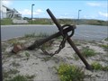
|   "Graveyard of the Atlantic" Anchor "Graveyard of the Atlantic" Anchor
in Anchors A small anchor in a parking lot. posted by:  Captain Chaoss Captain Chaoss location: North Carolina date approved: 10/11/2007 last visited: 07/05/2016 |
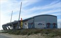 view gallery view galleryE2.7 km |  The Graveyard of the Atlantic Museum The Graveyard of the Atlantic Museum
in History Museums A small museum highlighting local sea-faring history and wrecks. posted by: Captain Chaoss location: North Carolina date approved: 10/08/2007 last visited: 05/18/2016 |
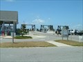 view gallery view gallery NE2.9 km NE2.9 km
|  Cape Hatteras Ferry Terminal, North Carolina Ferry System Cape Hatteras Ferry Terminal, North Carolina Ferry System
in Ferries and Ferry Landings The Cape Hatteras Ferry Terminal is the northern terminus of the Ocracoke - Cape Hatteras ferry run. posted by:  showbizkid showbizkid location: North Carolina date approved: 06/27/2006 last visited: 07/11/2013 |
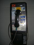
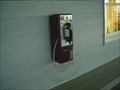 view gallery view galleryNE2.9 km |  NC DOT Ferry Stop - Hatteras, NC #1413 NC DOT Ferry Stop - Hatteras, NC #1413
in Payphones One of two pay phones outside the "Ship's Store" at the Hatteras ferry landing. posted by: fatcat161 location: North Carolina date approved: 05/11/2009 last visited: 05/17/2012 |
 view gallery view galleryNE2.9 km | NC DOT Ferry Stop - Hatteras, NC #1412 in Payphones ?One of two pay phones outside the "Ship's Store" at the Hatteras ferry landing. posted by: fatcat161 location: North Carolina date approved: 05/11/2009 last visited: never |
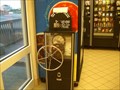 view gallery view galleryE2.9 km |  Ocracoke Ferry Penny Press Ocracoke Ferry Penny Press
in Penny Smashers The Penny Press is inside "The Ship's Store" at the southern Ocracoke Ferry Landing on Hatteras Island. posted by: fatcat161 location: North Carolina date approved: 05/21/2009 last visited: never |
 view gallery view gallery W4.3 km W4.3 km
| Ocracoke Island North Ferry Terminal, North Carolina Ferry System in Ferries and Ferry Landings The Ocracoke Island North Ferry Terminal is used for the Ocracoke to Hatteras ferry run. posted by: showbizkid location: North Carolina date approved: 06/27/2006 last visited: 05/24/2007 |
 view gallery view galleryNE4.5 km |  Hatteras Volunteer Fire Department Hatteras Volunteer Fire Department
in Firehouses Hatteras Volunteer Fire Department is the VFD for the town of Hatteras on North Carolina's Outer Banks. posted by: showbizkid location: North Carolina date approved: 07/01/2006 last visited: 06/14/2012 |
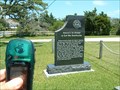
 view gallery view galleryNE4.5 km |  America's First Attempt at Reunification America's First Attempt at Reunification
in North Carolina Historical Markers The residents on the Outer Banks were largely Unionist and most did not support North Carolina's secession from the Union. This marker commemorates what is called "America's First Attempt at Unification" when Hatteras citizens petitioned the Union Army to state that they didn't support the secession and wished to remain citizens of the United States. posted by: showbizkid location: North Carolina date approved: 07/01/2006 last visited: 08/09/2016 |
 view gallery view galleryNE4.5 km |  America's First Attempt at Reunification, Hatteras, North Carolina America's First Attempt at Reunification, Hatteras, North Carolina
in Civil War Discovery Trail Sites The residents on the Outer Banks were largely Unionist and did not support North Carolina's secession from the Union. This marker commemorates what is called here "America's First Attempt at Unification." posted by: showbizkid location: North Carolina date approved: 07/01/2006 last visited: 08/09/2016 |
 view gallery view galleryNE4.5 km |  FIRST - Attempt at Civil War Reunification FIRST - Attempt at Civil War Reunification
in First of its Kind The residents on the Outer Banks of North carolina were largely Unionist and did not support North Carolina's secession from the Union in 1861. This marker commemorates what is called here "America's First Attempt at Civil War Reunification." posted by: showbizkid location: North Carolina date approved: 07/04/2006 last visited: 08/09/2016 |
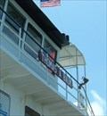
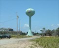 view gallery view galleryNE5.5 km |  Dare County Water Tower, Hatteras, North Carolina Dare County Water Tower, Hatteras, North Carolina
in Water Towers "Bulb" type tank in Hatteras, North Carolina on the Outer Banks. posted by: showbizkid location: North Carolina date approved: 07/24/2006 last visited: 06/25/2010 |
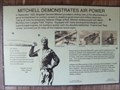 view gallery view galleryE10.6 km |  Mitchell Demonstrates Air Power -- Near Frisco in Dare County, North Carolina Mitchell Demonstrates Air Power -- Near Frisco in Dare County, North Carolina
in Signs of History My children in their lifetime will see aeronautics become the greatest and principal means of national defense and rapid transportation all over the world and possibly beyond our world into interstellar space posted by: Countrydragon location: North Carolina date approved: 01/25/2010 last visited: never |
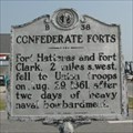 view gallery view galleryNE11.6 km | CONFEDERATE FORTS --- B-38 in North Carolina Historical Markers Located on NC 12, Hatteras, NC, USA posted by: Countrydragon location: North Carolina date approved: 01/25/2010 last visited: 08/09/2016 |
 view gallery view galleryNE12.2 km | Frisco Volunteer Fire Department in Firehouses Frisco Volunteer Fire Department was established in 1976. Happy 30th birthday! posted by: VirginiaSeeker location: North Carolina date approved: 08/05/2006 last visited: 06/22/2007 |
 view gallery view galleryNE12.6 km |  Outer Banks UFO House- Frisco NC Outer Banks UFO House- Frisco NC
in Roadside Attractions Outer Banks UFO House- Frisco NC, a unique UFO shaped house on the Outer Banks. posted by: kJfishman location: North Carolina date approved: 09/30/2011 last visited: 05/16/2015 |
 view gallery view galleryNE12.6 km |  UFO House UFO House
in Odd-Shaped Buildings UFO House posted by: kJfishman location: North Carolina date approved: 03/18/2008 last visited: 05/16/2015 |
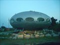 view gallery view galleryNE12.6 km |  UFO House - Probe - Frisco, NC, USA UFO House - Probe - Frisco, NC, USA
in Zippy the Pinhead Locations This UFO House made the Zippy strip on Aug 2, 2002. posted by: fatcat161 location: North Carolina date approved: 06/11/2009 last visited: 05/16/2015 |
 view gallery view galleryNE12.6 km |  UFO House Buxton NC UFO House Buxton NC
in Googie Architecture UFO House Buxton NC posted by: kJfishman location: North Carolina date approved: 05/12/2010 last visited: 05/16/2015 |
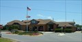
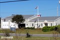 view gallery view galleryNE15.4 km |  Dare County EMS - Station No. 3 - Frisco, North Carolina Dare County EMS - Station No. 3 - Frisco, North Carolina
in Paramedic Stations This Station of Dare County EMS is located at 50346 NC Highway 12 in Frisco, Dare County, North Carolina. posted by: outdoorboy34 location: North Carolina date approved: 09/24/2011 last visited: 09/09/2011 |
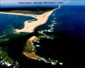 view gallery view galleryE18.3 km |  Cape Point Cape Point
in Wavy Places Cape Point, where the gulf stream meats the Labrador Current. posted by: fishingdude720 location: North Carolina date approved: 05/15/2006 last visited: 03/22/2011 |
 E19 km |  British Cemetery near Cape Hatteras Lighthouse British Cemetery near Cape Hatteras Lighthouse
in Out of Place Graves British Cemetery on Hatteras Island near the Cape Hatteras Lighthouse posted by: rtmlee location: North Carolina date approved: 07/02/2007 last visited: 05/14/2023 |
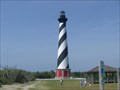 view gallery view galleryE19.3 km |  Cape Hatteras Lighthouse Cape Hatteras Lighthouse
in Relocated Structures Cape Hatteras Lighthouse was move back from the ocean in 1999. posted by: fatcat161 location: North Carolina date approved: 05/05/2009 last visited: 09/27/2022 |
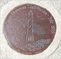 view gallery view galleryE19.3 km |  Cape Hatteras Light House NC Geodetic Survey Cape Hatteras Light House NC Geodetic Survey
in U.S. Benchmarks Cape Hatteras Light House NC Geodetic Survey posted by: kJfishman location: North Carolina date approved: 03/23/2008 last visited: 05/18/2016 |
 view gallery view galleryE19.3 km |  The Big Move - Cape Hatteras, NC The Big Move - Cape Hatteras, NC
in News Article Locations On June 5, 1999 The National Park Service began moving the lighthouse and its outbuildings 2900 feet. posted by: fatcat161 location: North Carolina date approved: 10/16/2009 last visited: 05/14/2023 |
|