 view gallery view gallery W4.3 km W4.3 km
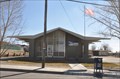
|   Oro Grande, California 92368 Oro Grande, California 92368
in U.S. Post Offices This Post Office is located at 15155 Olive Street in Oro Grande, California. posted by:  brwhiz brwhiz location: California date approved: 02/14/2012 last visited: never |
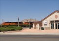
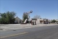 view gallery view galleryW4.7 km |  Oro Grande Garage, Mohawk Service Station and Mini Mart - Oro Grande, CA Oro Grande Garage, Mohawk Service Station and Mini Mart - Oro Grande, CA
in Route 66 - The Mother Road Abandoned Mohawk brand service station and mini mart. posted by:  Wallyum Wallyum location: California date approved: 05/15/2021 last visited: 04/14/2017 |
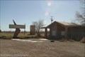 view gallery view galleryW5 km |  Googie Ghost Business - Oro Grande, CA Googie Ghost Business - Oro Grande, CA
in Googie Architecture This run down business displaying Googie architecture is located across from the Riverside Cement Company along Route 66/National Trails Hwy in Oro Grande. posted by: DopeyDuck location: California date approved: 02/20/2009 last visited: never |
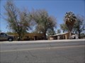 view gallery view galleryW5 km | Motor Inn Auto Court - Oro Grande, CA in Route 66 - The Mother Road Former Route 66 travel court. posted by: Wallyum location: California date approved: 05/29/2021 last visited: never |
 view gallery view gallery SW5 km SW5 km
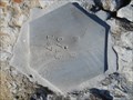
|  PB 0713 1976 Gravity Station Victorville, CA PB 0713 1976 Gravity Station Victorville, CA
in U.S. Benchmarks Gravity Station sharing a boulder with a NGS Benchmark EV0197 posted by: Team Geo-Clarks location: California date approved: 12/02/2013 last visited: never |
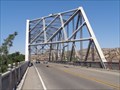 view gallery view gallerySW5.1 km | Rockfield Bridge - Route 66 - Oro Grande, California, USA. in Route 66 - The Mother Road The 1930 Rockfield Bridge - Also known as Route 66 Bridge. A skewed, Baltimore Truss Bridge, carrying the National Trails Highway, (Old Route 66) across The Mojave Desert River at Oro Grande, California. posted by: veritas vita location: California date approved: 12/22/2014 last visited: 04/14/2017 |
 view gallery view gallerySW5.1 km |  Historic Route 66 - Rockfield Bridge - Oro Grande, California, USA Historic Route 66 - Rockfield Bridge - Oro Grande, California, USA
in National Scenic Byways The 1930 Rockfield Bridge - Also known as Route 66 Bridge. A skewed, Baltimore Truss Bridge, carrying the National Trails Highway, (Old Route 66) across The Mojave Desert River at Oro Grande, California. posted by: veritas vita location: California date approved: 12/22/2014 last visited: 05/26/2014 |
 view gallery view gallerySW5.1 km |  Rockfield Bridge - Baltimore Truss - Oro Grande, California, USA. Rockfield Bridge - Baltimore Truss - Oro Grande, California, USA.
in Truss Bridges The 1930 Rockfield Bridge - Also known as Route 66 bridge. Is a skewed & modified, Baltimore Truss Bridge, It carries the National Trails Highway, (Old Route 66) across The Mojave Desert River at Oro Grande, California. posted by: veritas vita location: California date approved: 12/22/2014 last visited: 05/26/2014 |
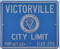 view gallery view gallerySW5.1 km |  Victorville, California ~ Population 107,221 Victorville, California ~ Population 107,221
in Population Signs This sign is on the National Trails Highway (Historic Route 66) at the northern edge of Victorville. posted by: brwhiz location: California date approved: 03/15/2012 last visited: 05/26/2014 |
 view gallery view gallerySW5.1 km |  Victorville, California ~ Elevation 2715 Victorville, California ~ Elevation 2715
in Elevation Signs This sign is on the National Trails Highway (Historic Route 66) at the northern edge of Victorville. posted by: brwhiz location: California date approved: 03/15/2012 last visited: 05/26/2014 |
 view gallery view gallery N5.5 km N5.5 km
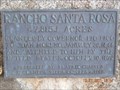
|  Rancho Santa Rosa Adobe marker Rancho Santa Rosa Adobe marker
in E Clampus Vitus Historical Markers Santa Rosa Plateau Vitus Clampus Marker. posted by: toponym location: California date approved: 12/30/2011 last visited: never |
 view gallery view gallery NW5.6 km NW5.6 km
| Iron Hog Saloon - Route 66 - Oro Grande, California, USA. in Route 66 - The Mother Road 'Iron Hog Saloon' - Formerly the 'Lost Hawg Saloon' Located alongside The National Trails Hwy, Route 66, Oro Grande, California, USA. posted by: veritas vita location: California date approved: 12/22/2014 last visited: 05/25/2014 |
 view gallery view galleryNW5.6 km | Historic Route 66 - Iron Hog Saloon - Oro Grande, California, USA. in National Scenic Byways 'Iron Hog Saloon' - Formerly the 'Lost Hawg Saloon' Located alongside The National Trails Hwy, Route 66, Oro Grande, California, USA. posted by: veritas vita location: California date approved: 12/22/2014 last visited: 05/25/2014 |
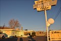 view gallery view gallerySW6 km |  Emma Jeans Holland Burger Café ~ Victorville, California Emma Jeans Holland Burger Café ~ Victorville, California
in Independent Diners Emma Jeans Holland Burger Café is located at 17143 North D Street (Old Route 66) in Victorville, California. posted by: brwhiz location: California date approved: 12/14/2012 last visited: 04/14/2017 |
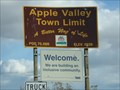 view gallery view gallery NE7.6 km NE7.6 km
|  Apple Valley, CA Apple Valley, CA
in Welcome Signs Apple Valley, CA posted by: imlosthere location: California date approved: 02/20/2008 last visited: 08/16/2015 |
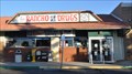 view gallery view gallery S7.7 km S7.7 km
| Apple Valley, California 92307 ~ Rancho Drugs CPU in U.S. Post Offices This Post Office is located at 17798 State Highway 18 in Apple Valley, California. posted by: brwhiz location: California date approved: 01/08/2012 last visited: 02/02/2012 |
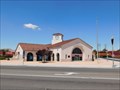 view gallery view galleryS8 km |  Victorville Amtrak Station - Victorville, CA Victorville Amtrak Station - Victorville, CA
in Wikipedia Entries A bus, train, and car hub in Victorville. posted by: bluesnote location: California date approved: 10/25/2015 last visited: 10/25/2015 |
 view gallery view galleryS8 km |  Victorville Transportation Center - Victorville, CA Victorville Transportation Center - Victorville, CA
in Train Stations/Depots A bus, train, and car hub in Victorville. posted by: bluesnote location: California date approved: 10/25/2015 last visited: 10/25/2015 |
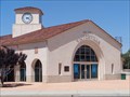 view gallery view galleryS8 km |  Victor Valley Transportation Center - Town Clock - Victorville, California, USA Victor Valley Transportation Center - Town Clock - Victorville, California, USA
in Town Clocks Victorville Transportation Center - Features a four sided clock tower. A hub for Trains & Buses. Serving Amtrak & BNSF trains, also Greyhound Buses, & the Victor Valley Transit Authority Buses, Located in Victorville, California. posted by: veritas vita location: California date approved: 10/28/2015 last visited: 10/31/2015 |
 view gallery view galleryS8 km |  Victorville Transportation Center - 1999 - Victorville, CA Victorville Transportation Center - 1999 - Victorville, CA
in Dated Architectural Structures Multifarious A bus, train, and car hub in Victorville. posted by: bluesnote location: California date approved: 10/26/2015 last visited: 10/26/2015 |
 view gallery view galleryS8 km |  Victor Valley Transportation Center - Victorville, California, USA. Victor Valley Transportation Center - Victorville, California, USA.
in Active Rail Locations Victorville Transportation Center - A hub for Trains & Buses. Only 2 Amtrak trains, but dozens of BNSF freight trains, pass daily, up to a mile long, some being pushed or pulled by as many as six Locomotives. Located in Victorville, California. posted by: veritas vita location: California date approved: 10/26/2015 last visited: 10/26/2015 |
 view gallery view galleryS8 km |  Victorville Transportation Center - Victorville, CA Victorville Transportation Center - Victorville, CA
in Bus Stations A bus, train, and car hub in Victorville. posted by: bluesnote location: California date approved: 10/26/2015 last visited: 10/26/2015 |
 view gallery view galleryS8 km |  Victorville Transportation Center - Victorville, CA Victorville Transportation Center - Victorville, CA
in Satellite Imagery Oddities A bus, train, and car hub in Victorville. posted by: bluesnote location: California date approved: 05/27/2015 last visited: 05/27/2015 |
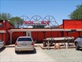
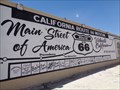 view gallery view galleryS8 km |  Route 66 - LUCKY - Victorville, California, USA. Route 66 - LUCKY - Victorville, California, USA.
in Lucky 7 California 'Route 66 Museum' The anchor point of this Lucky 7, scoring a Tally of 14. The Museum itself is located in a historic building. A former roadhouse called the 'Red Rooster' Located in Victorville, California. posted by: veritas vita location: California date approved: 10/25/2015 last visited: 02/23/2016 |
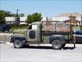 view gallery view galleryS8 km |  Santa Monica or Bust - Victorville, CA Santa Monica or Bust - Victorville, CA
in Permanent Car Displays A car on display outside the California Route 66 Museum. posted by: bluesnote location: California date approved: 04/08/2016 last visited: 02/21/2018 |
|