 view gallery view gallery SW8.7 km SW8.7 km
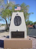
|   McMullen Valley 9/11 Memorial - Salome, Arizona McMullen Valley 9/11 Memorial - Salome, Arizona
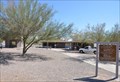
in 9/11 Memorial Sites After 3 years of planning, fundraising, and hard work, this little desert community has made their dream come true ~ a beautiful, awe inspiring, 911 Memorial that sits alongside of Hwy 60 for all to see and reflect. posted by:  leadhiker leadhiker location: Arizona date approved: 06/16/2010 last visited: 01/21/2019 |
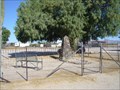 view gallery view gallerySW8.9 km |  Dick Wick Hall - Salome, AZ Dick Wick Hall - Salome, AZ
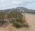
in Grave of a Famous Person Dick Wick Hall
founder of ~
Salome "Where She Danced" Arizona posted by: leadhiker location: Arizona date approved: 06/14/2010 last visited: never |
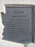 view gallery view gallerySW8.9 km |  Salome Salome
in Arizona Historical Markers According to Dick Wick Hall ~ Mrs. Salome Pratt took off her shoes and danced across the hot sand that burned her feet. Thus, the town became "Salome ~ where she danced ~ Arizona." posted by: leadhiker location: Arizona date approved: 06/15/2010 last visited: 05/27/2018 |
 view gallery view gallery S9.5 km S9.5 km
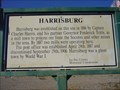
| Harrisburg in Arizona Historical Markers Harrisburg may have been referred to as Orville and or Centennial. posted by: leadhiker location: Arizona date approved: 06/15/2010 last visited: never |
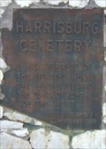 view gallery view galleryS10.1 km | Harrisburg Cemetery in Arizona Historical Markers In 1849, a group of pioneers heading for California were slaughtered by Indians. Several months later a party of gold seekers found their bones and buried them on the Harrisburg Cemetery knoll. posted by: leadhiker location: Arizona date approved: 10/24/2011 last visited: never |
 view gallery view gallerySW14 km |  Mushroom Rock Mushroom Rock
in Nature's Balanced Rocks A sandstone rock shaped like a large mushroom.
posted by:  rjacky rjacky location: Arizona date approved: 02/27/2008 last visited: 03/28/2014 |
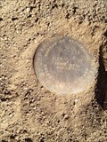 view gallery view gallerySW18 km |  Department of the Interior Bureau of reclamation Department of the Interior Bureau of reclamation
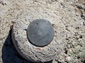
in U.S. Benchmarks N 33° 42.659 W 113° 40.507 very near to this geocache point...in the NE section of the intersection of the trails. posted by: RangerRicksClan location: Arizona date approved: 02/26/2012 last visited: 04/09/2012 |
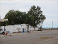
 view gallery view gallerySW22.9 km |  Passmore Gas & Propane Passmore Gas & Propane
in Unintentionally Funny Signs Out in the desert southwest no one could hear you fart. You're darn tootin! posted by: leadhiker location: Arizona date approved: 06/17/2010 last visited: 01/19/2019 |
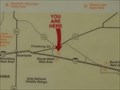 view gallery view gallerySW25.6 km |  Bouse Wash Westbound Rest Area #1 Bouse Wash Westbound Rest Area #1
in 'You Are Here' Maps You Are Here at the Bouse Wash Westbound Rest Area on Interstate Highway 10 at about mile marker 52, east of Quartzite, Arizona. posted by: brwhiz location: Arizona date approved: 11/22/2012 last visited: 03/25/2014 |
 view gallery view gallerySW25.6 km |  The Sonoran desert The Sonoran desert
in Flora and Fauna Information Signs This Flora and Fauna Information Sign is located in the Bouse Wash Westbound Rest Area on Interstate Highway 10 at about mile marker 52, east of Quartzite, Arizona. posted by: brwhiz location: Arizona date approved: 11/26/2012 last visited: 03/25/2014 |
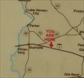 view gallery view gallerySW25.6 km | Bouse Wash Westbound Rest Area #2 in 'You Are Here' Maps You Are Here at the Bouse Wash Westbound Rest Area on Interstate Highway 10 at about mile marker 52, east of Quartzite, Arizona. posted by: brwhiz location: Arizona date approved: 11/22/2012 last visited: 03/25/2014 |
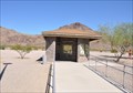
 view gallery view gallerySW25.6 km |  Bouse Wash Westbound Rest Area Bouse Wash Westbound Rest Area
in Highway Rest Areas The Bouse Wash Westbound Rest Area is located on Interstate Highway 10 at about mile marker 86, east of Quartzite, Arizona. posted by: brwhiz location: Arizona date approved: 11/22/2012 last visited: 03/25/2014 |
 view gallery view gallery SE33.2 km SE33.2 km
| Avenue 75 Arizona Highway Marker - Tonopah, AZ in U.S. Benchmarks This marker is located at the northeast corner of the Avenue 75 exit from Interstate 10. posted by: rjmcdonough1 location: Arizona date approved: 10/09/2018 last visited: never |
 view gallery view gallery E34.1 km E34.1 km
|  "Eagele Eye Cemetary" - Aguila, Arizona "Eagele Eye Cemetary" - Aguila, Arizona
in Human Error The name of the Eagle Eye Cemetery seems to have taken on a new spelling. posted by: T2D location: Arizona date approved: 06/11/2019 last visited: never |
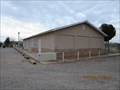
 view gallery view galleryE34.1 km |  Eagle Eye Cemetery - Aguila, Arizona Eagle Eye Cemetery - Aguila, Arizona
in Worldwide Cemeteries Eagle Eye Cemetery, a very quiet cemetery with views that lend to lots of peace and the ability to just breathe! posted by: T2D location: Arizona date approved: 01/23/2019 last visited: 01/23/2019 |
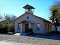 view gallery view galleryE35.9 km |  Community Bible Church Bell Tower - Aguila, AZ Community Bible Church Bell Tower - Aguila, AZ
in Bell Towers This short tower houses the bell atop the Community Bible Church. posted by: rjmcdonough1 location: Arizona date approved: 02/02/2019 last visited: never |
 view gallery view galleryE35.9 km |  Community Bible Church - Aguila, AZ Community Bible Church - Aguila, AZ
in Religious Buildings Multifarious The Community Bible Church is located on 1st Ave. in Aguila, Arizona. posted by: rjmcdonough1 location: Arizona date approved: 01/24/2019 last visited: never |
 view gallery view galleryE36.2 km |  Aguila, AZ Aguila, AZ
in Wikipedia Entries Aguila is a census designated place in the northwest corner of Maricopa County, Arizona. posted by: rjmcdonough1 location: Arizona date approved: 01/24/2019 last visited: never |
 view gallery view galleryE36.4 km | Iglesia Evangelica Nazaret - Aguila, AZ in Religious Buildings Multifarious This building houses the Evangelical Church of Christ in the community of Aguila. posted by: rjmcdonough1 location: Arizona date approved: 01/23/2019 last visited: never |
 view gallery view gallery W44.7 km W44.7 km
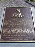
| Camp Bouse in Arizona Historical Markers Monument Row in Bouse Arizona is dedicated to the various battalions that trained at Camp Bouse. Camp Bouse was established in 1942 by Gen George Patton as one of the eleven bases of his "Desert Training Center". 9000 GI's were housed there. posted by: leadhiker location: Arizona date approved: 05/19/2010 last visited: 12/27/2020 |
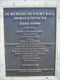 view gallery view galleryW44.7 km |  In Memory of Eight Ball Moral Officer In Memory of Eight Ball Moral Officer
in E Clampus Vitus Historical Markers Eight Ball was a male burro about three years old. He came into Camp Bouse during WWII and soon became the mascot of the camp and soldiers. He was very tame and friendly and the troops were very fond of him. posted by: leadhiker location: Arizona date approved: 05/19/2010 last visited: 12/27/2020 |
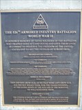 view gallery view galleryW44.7 km | The 526th Armored Infantry Battalion in E Clampus Vitus Historical Markers Monument Row in Bouse Arizona is dedicated to the various battalions that trained at Camp Bouse. Camp Bouse was established in 1942 by Gen George Patton as one of the eleven bases of his "Desert Training Center". 9000 GI's were housed there. posted by: leadhiker location: Arizona date approved: 05/19/2010 last visited: 12/27/2020 |
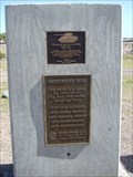 view gallery view galleryW44.7 km | 738th Medium Tank Battalion, Special in E Clampus Vitus Historical Markers Monument Row in Bouse Arizona is dedicated to the various battalions that trained at Camp Bouse. Camp Bouse was established in 1942 by Gen George Patton as one of the eleven bases of his "Desert Training Center". 9000 GI's were housed there. posted by: leadhiker location: Arizona date approved: 05/19/2010 last visited: 12/27/2020 |
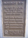 view gallery view galleryW44.7 km | Monument Row in E Clampus Vitus Historical Markers Monument Row in Bouse Arizona is dedicated to the various battalions that trained at Camp Bouse. Camp Bouse was established in 1942 by Gen George Patton as one of the eleven bases of his "Desert Training Center". 9000 GI's were housed there. posted by: leadhiker location: Arizona date approved: 05/19/2010 last visited: never |
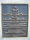 view gallery view galleryW44.7 km | 739th Tank Battalion (SP) (ME) in E Clampus Vitus Historical Markers Monument Row in Bouse Arizona is dedicated to the various battalions that trained at Camp Bouse. Camp Bouse was established in 1942 by Gen George Patton as one of the eleven bases of his "Desert Training Center". 9000 GI's were housed there. posted by: leadhiker location: Arizona date approved: 05/18/2010 last visited: 12/27/2020 |
|