 view gallery view gallery NW10.1 km NW10.1 km
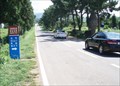
|   Mysterious Road - Jeju, Korea Mysterious Road - Jeju, Korea
in Vortexes, Mystery Spots, and Gravity Hills Just a short distance from Jeju City is this short stretch of road where a car appears to roll freely uphill. It is a regular destination for tour buses. posted by:  silverquill silverquill location: Jejudo, Korea date approved: 09/11/2010 last visited: never |
 view gallery view gallery S13.7 km S13.7 km
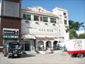
|  Seogwipo Wedding Hall (서귀포 웨딩홀) - Seogwipo, Korea Seogwipo Wedding Hall (서귀포 웨딩홀) - Seogwipo, Korea
in Wedding Chapels This wedding hall is located in the south, central part of the town of Seogwipo on Jeju Island, with a beautiful view of the South Sea. posted by: silverquill location: Jejudo, Korea date approved: 01/15/2013 last visited: never |
 view gallery view gallery N14.2 km N14.2 km
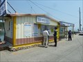
|  McDonald's Drive-Thru - Rt. 1139 - Jeju City, Korea McDonald's Drive-Thru - Rt. 1139 - Jeju City, Korea
in McDonald's Restaurants This McDonald's is located at a busy 5-way intersection of Jeju City in Korea's special self-governing island province. What makes it unusual is not it's two-story design, but the drive-thru and stand alone design - both still very uncommon in Korea. posted by: silverquill location: Jejudo, Korea date approved: 09/11/2010 last visited: never |
 view gallery view galleryN103.6 km |  Land's End Ferry 땅끝 여객선 - Ttangkkeut, Korea Land's End Ferry 땅끝 여객선 - Ttangkkeut, Korea
in Ferries and Ferry Landings Depicted is the ticket office for the many ferries that leave from this pier with service to many islands on the South Sea of Korea. posted by: silverquill location: Jeolla nam do, Korea date approved: 01/13/2013 last visited: never |
 view gallery view galleryN103.6 km |  Ttangkkeut Haean Tourist Information Center (땅끝 해안 관광안내소) - Haean, Korea Ttangkkeut Haean Tourist Information Center (땅끝 해안 관광안내소) - Haean, Korea
in Tourist Information Centers - Visitor Centers This new tourist information office is located at the south of City Park next to the ferry ticket office in the center of the harbor town of Ttangkkeut, Korea. posted by: silverquill location: Jeolla nam do, Korea date approved: 01/14/2013 last visited: never |
 view gallery view galleryN103.6 km |  34 17' 21" (N) - Ttangkkeut, Korea 34 17' 21" (N) - Ttangkkeut, Korea
in Permanent Geographic Coordinates This sign bears the coordinates of the most southern point on the Korean peninsula. posted by: silverquill location: Jeolla nam do, Korea date approved: 01/07/2013 last visited: never |
 view gallery view galleryN103.6 km |  Relief Map of Korea - Land's End, Korea Relief Map of Korea - Land's End, Korea
in Relief Art Sculptures This granite relief sculpture represents the Korean peninsula. It is dedicated to national reunification and is located at "Land's End," the most southern point on the peninsula. posted by: silverquill location: Jeolla nam do, Korea date approved: 01/06/2013 last visited: never |
 view gallery view galleryN103.6 km |  Korean Peninsula - Ttangkkeut, Korea Korean Peninsula - Ttangkkeut, Korea
in 3D Map Models of Our World and Beyond This granite 3-D map represents the Korean peninsula. It is dedicated to national reunification and is located at "Land's End," the most southern point on the peninsula. posted by: silverquill location: Jeolla nam do, Korea date approved: 01/06/2013 last visited: never |
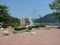 view gallery view galleryN103.6 km |  City Park - Land's End, Korea City Park - Land's End, Korea
in Municipal Parks and Plazas This park and plaza area is in the center of the port town of Ttangkkeut, known as the most southern point on the Korean peninisula. posted by: silverquill location: Jeolla nam do, Korea date approved: 01/06/2013 last visited: never |
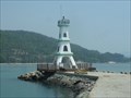 view gallery view galleryN103.8 km |  Galdu Harbor Breakwater Lighthouse (갈두항방파제등대) - Ttangkkeut, Korea Galdu Harbor Breakwater Lighthouse (갈두항방파제등대) - Ttangkkeut, Korea
in Coastal Lighthouses Designed to resemble the Eiffel Tower, this lighthouse guards to entrance to Galdu Harbor, also known as Land's End - the most southern point on the Korean peninsula. posted by: silverquill location: Jeolla nam do, Korea date approved: 01/12/2013 last visited: never |
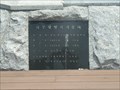 view gallery view galleryN103.8 km |  October 18, 2000 - Galdu Harbor Breakwater Lighthouse (갈두항방파제등대) - Ttangkkeut, Korea October 18, 2000 - Galdu Harbor Breakwater Lighthouse (갈두항방파제등대) - Ttangkkeut, Korea
in Dated Buildings and Cornerstones Designed to resemble the Eiffel Tower, this lighthouse guards to entrance to Galdu Harbor, also known as Land's End - the most southern point on the Korean peninsula. Construction began on July 28, 200 and was completed October 18,2000. posted by: silverquill location: Jeolla nam do, Korea date approved: 01/09/2013 last visited: never |
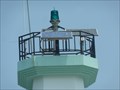 view gallery view galleryN103.8 km |  Galdu Harbor Breakwater Lighthouse (갈두항방파제등대) - Ttangkkeut, Korea Galdu Harbor Breakwater Lighthouse (갈두항방파제등대) - Ttangkkeut, Korea
in Solar Power Designed to resemble the Eiffel Tower, this lighthouse guards to entrance to Galdu Harbor, also known as Land's End - the most southern point on the Korean peninsula. The green light is powered by photovoltaic cells. posted by: silverquill location: Jeolla nam do, Korea date approved: 01/09/2013 last visited: never |
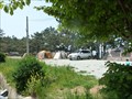 view gallery view galleryN105.3 km |  End of the Earth Auto Camping Resort 땅끝 오토캠핑 리조트 - Songho, Korea End of the Earth Auto Camping Resort 땅끝 오토캠핑 리조트 - Songho, Korea
in Campgrounds This is a campground on scenic Route 77 near "Land's End" Korea. posted by: silverquill location: Jeolla nam do, Korea date approved: 01/04/2013 last visited: never |
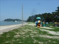 view gallery view galleryN105.3 km |  Songho Beach Playground - Songho, Korea Songho Beach Playground - Songho, Korea
in Public Playgrounds This small playground is located at the south end of Songho Beach, Korea. posted by: silverquill location: Jeolla nam do, Korea date approved: 01/04/2013 last visited: never |
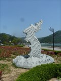
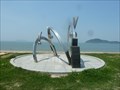 view gallery view galleryN105.3 km |  Songho Beach Sculpture - Songho, Korea Songho Beach Sculpture - Songho, Korea
in Abstract Public Sculptures This stainless steel sculpture is located at the south end of Songho Beach near a playground and camping area. posted by: silverquill location: Jeolla nam do, Korea date approved: 01/04/2013 last visited: never |
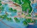 view gallery view galleryN105.6 km |  Haenam Map at Songho Beach - Songho, Korea Haenam Map at Songho Beach - Songho, Korea
in 'You Are Here' Maps This tourist guide map of the Haenam Peninsula is located at Songho Beach and the "Windbreak Pine Forest," National Monument 142, along scenic Route 77. posted by: silverquill location: Seoul, Korea date approved: 06/20/2012 last visited: never |
 view gallery view galleryN105.6 km |  Windbreak Pine Tree Forest in Shongho-ri (Monument No. 142) Windbreak Pine Tree Forest in Shongho-ri (Monument No. 142)
in Korean Historic Sites This stand of over 600 black pine trees is found along several kilometers of straight sand beach in thd small village of Songho, on the Haenam Peninsula, near the southernmost point on the Korean mainland. posted by: silverquill location: Jeolla nam do, Korea date approved: 06/19/2012 last visited: never |
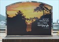
 view gallery view galleryN105.6 km |  Songho Wall Mural - Songho, Korea Songho Wall Mural - Songho, Korea
in Murals This mural stretches along the wall outside an elementary school across from the beach in the village of Songho on the Haenam Peninsula. posted by: silverquill location: Jeolla nam do, Korea date approved: 06/21/2012 last visited: never |
 view gallery view galleryN105.6 km |  Songho Beach (땅끝송호해변) - Songho, Korea Songho Beach (땅끝송호해변) - Songho, Korea
in Beaches This beach on the Haenam Peninsula is a nice stretch of sand flanked by the "Windbreak Pine Forest," National Monument 142, along scenic Route 77. posted by: silverquill location: Jeolla nam do, Korea date approved: 06/19/2012 last visited: never |
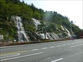 view gallery view galleryN107.5 km | Smiling Park - Wando, Korea in Municipal Parks and Plazas This spectacular park features a large artificial waterfall, about 60 feet high and extending for about 200 feet along the edge of a busy street in Wando, Korea. posted by: silverquill location: Jeolla nam do, Korea date approved: 01/10/2013 last visited: never |
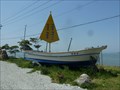 view gallery view galleryN110.1 km |  Land's End Boat (땅끝호) - Haenam, Korea Land's End Boat (땅끝호) - Haenam, Korea
in Landlocked Boats This small boat is on display at the beginning of a scenic road (Route 77) that extends around the Haean peninsula to the southern most point on the larger Korean peninsula. posted by: silverquill location: Jeolla nam do, Korea date approved: 06/19/2012 last visited: never |
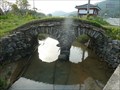
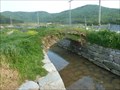 view gallery view galleryN116 km |  Danun Bridge (단운교) - Jindo, Korea Danun Bridge (단운교) - Jindo, Korea
in Stone Bridges This stone arch bridge is listed as Cultural Property No. 215 in South Jeolla Province, Korea, along with a companion double-arch bridge. It was probably built in the late 19th century. posted by: silverquill location: Seoul, Korea date approved: 01/11/2013 last visited: never |
 view gallery view galleryN116 km | Jindo Nandong-ri Ssangungyo and Danungyo (진도 남동리 쌍운교 및 만우교) - Jindo, Korea in Korean Historic Sites This Cultural Property consists of two small stone bridges near the Historic Site of the Namdoseokseong Fortress on Jindo Island on Korea's scenic southern coast. posted by: silverquill location: Jeolla nam do, Korea date approved: 01/11/2013 last visited: never |
 view gallery view galleryN116 km |  Danun Bridge (단운교) - Jindo, Korea Danun Bridge (단운교) - Jindo, Korea
in Arch Bridges This stone arch bridge is listed as Cultural Property No. 215 in South Jeolla Province, Korea, along with a companion double-arch bridge. It was probably built in the late 19th century. posted by: silverquill location: Jeolla nam do, Korea date approved: 01/11/2013 last visited: never |
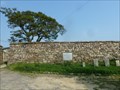 view gallery view galleryN116 km | Namdoseokseong (남도석성) - Jindo, Korea in Korean Historic Sites This historic fortress probably dates from the 15th century built as a defense against Japanese pirates. It has been well preserved and encloses as living village with many of the old buildings and walls freely open to the public. posted by: silverquill location: Jeolla nam do, Korea date approved: 01/11/2013 last visited: never |
|