 view gallery view gallery NE0.5 km NE0.5 km
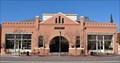
|   Ramona Town Hall ~ Ramona, California Ramona Town Hall ~ Ramona, California
in U.S. National Register of Historic Places The Ramona Town Hall, also known as Barnett Hall or Town Hall of Nuevo, was added to the National Register of Historic Places on September 6, 1994. posted by:  brwhiz brwhiz location: California date approved: 01/20/2011 last visited: never |
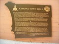 view gallery view galleryNE0.5 km |  Ramona Town Hall - Ramona, CA Ramona Town Hall - Ramona, CA
in E Clampus Vitus Historical Markers ECV plaque on the front of Ramona's Historic Town Hall. posted by:  Johnny_Quest Johnny_Quest location: California date approved: 06/01/2010 last visited: 12/27/2010 |
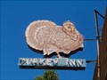 view gallery view galleryNE0.5 km |  Turkey Inn - Ramona, CA Turkey Inn - Ramona, CA
in Neon Signs Neon sign outside the Turkey Inn Tavern in Ramona, CA. posted by: Johnny_Quest location: California date approved: 06/04/2010 last visited: 04/25/2012 |
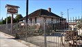 view gallery view galleryNE0.6 km | Verlaque, Theophile, House - Ramona, California in U.S. National Register of Historic Places The Theophile Verlaque House was added to the National Register of Historic Places on August 7, 1991. posted by: brwhiz location: California date approved: 01/20/2011 last visited: never |
 view gallery view galleryNE0.6 km | Verlaque House - E Clampus Vitus - Ramona, CA in E Clampus Vitus Historical Markers This ECV marker dedicates an adobe home of a Ramona pioneer. posted by: Johnny_Quest location: California date approved: 01/29/2012 last visited: 12/27/2010 |
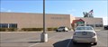
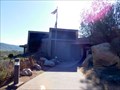
 view gallery view galleryNE0.6 km |  Ramona Mainstage - Ramona, California Ramona Mainstage - Ramona, California
in Concert Halls Ramona Mainstage is a multipurpose building on the main drag in Ramona whose history goes back over 70 years. posted by: =CCC= location: California date approved: 08/03/2016 last visited: 08/04/2016 |
 view gallery view gallery SW0.8 km SW0.8 km
|  Ramona, California 92065 Ramona, California 92065
in U.S. Post Offices This Post Office is located at 1444 Main Street in Ramona, California. posted by: brwhiz location: California date approved: 11/09/2011 last visited: never |
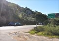
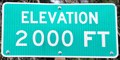 view gallery view galleryNE6.1 km |  Old Julian Highway ~ Elevation 2000 Feet Old Julian Highway ~ Elevation 2000 Feet
in Elevation Signs This Elevation Sign is on the east side of the Old Julian Highway (California Highway 78) just south of Rancho Santa Fe Court, about 4.7 miles northeast of Ramona, California. posted by: brwhiz location: California date approved: 12/10/2012 last visited: 08/14/2016 |
 view gallery view gallery W8.7 km W8.7 km
| Castle, The ~ Ramona, California in U.S. National Register of Historic Places The Castle, also known as the Amy Strong Castle or Mount Woodson Castle, was added to the National Register of Historic Places on March 30, 1978. posted by: brwhiz location: California date approved: 01/20/2011 last visited: 03/26/2011 |
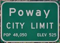 view gallery view gallerySW10 km |  Poway, California, Population 48,050 Poway, California, Population 48,050
in Population Signs This combination elevation/population sign greets you as you travel south into Poway on California Highway 67. posted by: brwhiz location: California date approved: 06/07/2011 last visited: never |
 view gallery view gallerySW10 km | Poway, California - Elevation 525 in Elevation Signs This combination elevation/population sign greets you as you travel south into Poway on California Highway 67. posted by: brwhiz location: California date approved: 06/07/2011 last visited: never |
 view gallery view gallerySW10 km |  Poway, California Poway, California
in Wikipedia Entries Poway, on the northeastern edge of Dan Diego, is primarily a bedroom community for its larger neighbor. posted by: brwhiz location: California date approved: 06/08/2011 last visited: never |
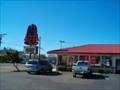 view gallery view gallerySW11.1 km |  Arby's - Woodside Ave. -Lakeside -CA Arby's - Woodside Ave. -Lakeside -CA
in Arby's Restaurants Arby's Restaurant in Lakeside, CA. posted by: Johnny_Quest location: California date approved: 01/26/2008 last visited: 04/23/2011 |
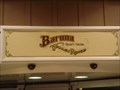 view gallery view gallery S11.4 km S11.4 km
|  Barona Valley Ranch Resort & Casino Barona Valley Ranch Resort & Casino
in Casinos Located just 30 minutes outside of San Diego, Barona offers gaming action, unique dining, a hotel, and world-class golf. With a history dating back to the 1930s when the Barona Tribe established a small ranching community, the Barona Reservation has now blossomed into one of "California’s best casino's". posted by: PassingWind location: California date approved: 08/16/2005 last visited: 02/20/2013 |
 view gallery view galleryS11.6 km |  Rumely Oilpull Tractor, Ramona, CA Rumely Oilpull Tractor, Ramona, CA
in Old Tractors This is a Rumely Oilpull tractor located at the Barona Casino on the Barona Indian Reservation in Ramona, CA. posted by: Johnny_Quest location: California date approved: 10/21/2007 last visited: never |
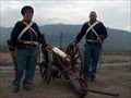 view gallery view gallery NW11.9 km NW11.9 km
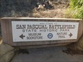
|  1846 Battle of San Pasqual, San Diego, CA, USA 1846 Battle of San Pasqual, San Diego, CA, USA
in Historic Reenactments San Pasqual Battlefield State Historic Park, honors the soldiers who fought in the battle between the U.S. and Californio forces on December 6, 1846 in the midst of the Mexican-American War. posted by: Johnny_Quest location: California date approved: 12/28/2008 last visited: 08/08/2015 |
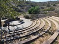 view gallery view galleryNW11.9 km |  San Pasqual Battlefield State Historic Park Amphitheater - Escondido, CA San Pasqual Battlefield State Historic Park Amphitheater - Escondido, CA
in Outdoor Amphitheaters A large amphitheater for a small state park. posted by: bluesnote location: California date approved: 08/12/2015 last visited: 08/12/2015 |
 view gallery view galleryNW11.9 km |  San Pasqual Battlefield State Historic Park - Escondido, CA San Pasqual Battlefield State Historic Park - Escondido, CA
in State/Provincial Parks A battlefield during the Mexican-American War. posted by: bluesnote location: California date approved: 08/12/2015 last visited: 08/12/2015 |
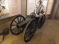 view gallery view galleryNW11.9 km |  San Pasqual Battlefield State Historic Park Cannons - Escondido, CA San Pasqual Battlefield State Historic Park Cannons - Escondido, CA
in Static Artillery Displays Two cannons sit near and in the visitor center, depending on the time of day. posted by: bluesnote location: California date approved: 08/13/2015 last visited: 08/13/2015 |
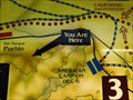 view gallery view galleryNW11.9 km |  San Pasqual Battlefield State Historic Park Map - Escondido, CA San Pasqual Battlefield State Historic Park Map - Escondido, CA
in 'You Are Here' Maps A YAH map located in the back of the museum. posted by: bluesnote location: California date approved: 08/12/2015 last visited: 08/12/2015 |
 view gallery view galleryNW11.9 km | San Pasqual Battlefield State Historic Park - Escondido, CA in Wikipedia Entries A battlefield during the Mexican-American War. posted by: bluesnote location: California date approved: 08/12/2015 last visited: 08/12/2015 |
 view gallery view galleryNW11.9 km |  San Pasqual Battlefield State Historic Park Museum - Escondido, CA San Pasqual Battlefield State Historic Park Museum - Escondido, CA
in History Museums A museum located inside the visitor center. posted by: bluesnote location: California date approved: 08/12/2015 last visited: 08/12/2015 |
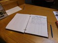 view gallery view galleryNW11.9 km |  San Pasqual Battlefield State Historic Park Guest Book - Escondido, CA San Pasqual Battlefield State Historic Park Guest Book - Escondido, CA
in Guest Books A guest book inside the visitor center of the state park. posted by: bluesnote location: California date approved: 08/13/2015 last visited: 08/13/2015 |
 view gallery view galleryNW11.9 km |  San Pasqual Battlefield State Historic Park Visitor Center - Escondido, CA San Pasqual Battlefield State Historic Park Visitor Center - Escondido, CA
in Tourist Information Centers - Visitor Centers The visitor center is located in the museum of the park. posted by: bluesnote location: California date approved: 08/13/2015 last visited: 08/13/2015 |
 view gallery view galleryNW11.9 km |  San Pasqual Battlefield State Historic Park - Escondido, CA San Pasqual Battlefield State Historic Park - Escondido, CA
in Official Local Tourism Attractions A battlefield during the Mexican-American War. posted by: bluesnote location: California date approved: 08/12/2015 last visited: 08/12/2015 |
|