 view gallery view gallery E0.5 km E0.5 km
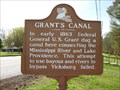
|   Grant's Canal Grant's Canal
in Louisiana Historical Markers This historical marker is located along U.S. Highway 65 in a small park appropriately named Grant's Canal Park in Lake Providence, Louisiana. posted by:  Marine Biologist Marine Biologist location: Louisiana date approved: 04/04/2010 last visited: 10/17/2015 |
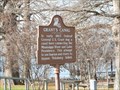 view gallery view galleryE0.5 km | Grant's Canal - Lake Providence in Louisiana Historical Markers Grant's Canal marker at Lake Providence Visitor's Center - 600 Lake Street, Lake Street and Ingram St. posted by:  kwashnak kwashnak location: Louisiana date approved: 05/31/2010 last visited: 11/01/2015 |
 view gallery view gallery NW0.8 km NW0.8 km
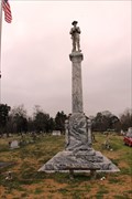
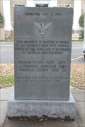
|  Confederate Soldier's Memorial, Lake Providence, LA Confederate Soldier's Memorial, Lake Providence, LA
in American Civil War Monuments and Memorials Confederate Soldier Memorial, City Cemetery, Lake Providence, Louisiana posted by: kwashnak location: Louisiana date approved: 04/17/2014 last visited: never |
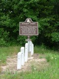
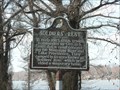 view gallery view galleryNW0.8 km | Soldiers' Rest in Louisiana Historical Markers 1234 Lake Street, Lake Providence near cemetery posted by: kwashnak location: Louisiana date approved: 05/31/2010 last visited: 10/17/2015 |
 view gallery view galleryE0.8 km |  Destiny Words - Lake Providence LA Destiny Words - Lake Providence LA
in Murals Located on Sparrow St at its intersection with Lake St posted by: nomadwillie location: Louisiana date approved: 01/13/2017 last visited: never |
 view gallery view gallery S13.4 km S13.4 km
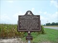
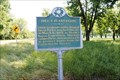
| Transylvania Mounds in Louisiana Historical Markers Transylvania Mounds are located on LA hwy 581, 1.3 miles west of US 65 posted by: kwashnak location: Louisiana date approved: 07/21/2011 last visited: 10/17/2015 |
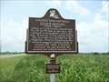 view gallery view galleryS13.5 km | Julice Mound in Louisiana Historical Markers From US 65, head west on La 581. Go 2.2 miles (past intersection
with La 881) to marker on right. posted by: kwashnak location: Louisiana date approved: 12/21/2011 last visited: 10/17/2015 |
 view gallery view galleryS14.2 km |  Transylvania, LA 71286 Transylvania, LA 71286
in U.S. Post Offices Located on US 65 posted by: nomadwillie location: Louisiana date approved: 01/15/2017 last visited: 09/15/2019 |
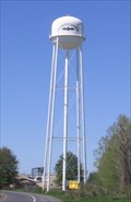 view gallery view galleryS14.6 km |  A Batty Water Tower A Batty Water Tower
in Water Towers Everything looked like Louisiana but this tower seems to be strayed from the pages of "Dracula!" posted by: GeoGrands location: Louisiana date approved: 04/03/2006 last visited: 09/15/2019 |
 view gallery view gallery NE15.9 km NE15.9 km
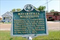
|  Mayersville, Mississippi Mayersville, Mississippi
in Mississippi Historical Markers Marker located at the Issaquena County Courthouse, 129 Court Street in Mayersville, MS. posted by: kwashnak location: Mississippi date approved: 05/28/2013 last visited: 05/31/2016 |
 view gallery view gallery W20.4 km W20.4 km
|  West Carroll Parish Veteran's Memorial - Oak Grove, LA West Carroll Parish Veteran's Memorial - Oak Grove, LA
in Non-Specific Veteran Memorials Memorial to veterans from the parish located on the lawn of the West Carroll Parish Courthouse, East Main Street (Route 2) in Oak Grove, LA posted by: kwashnak location: Louisiana date approved: 06/11/2015 last visited: 09/15/2019 |
 view gallery view gallery N22.5 km N22.5 km
|  AR / LA US 65 - Eudora AR AR / LA US 65 - Eudora AR
in Border Crossings Located along US 65 heading north from Louisiana into Arkansas posted by: nomadwillie location: Arkansas date approved: 01/13/2017 last visited: never |
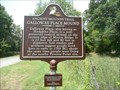 view gallery view galleryNW22.9 km | Galloway Place Mound in Louisiana Historical Markers Galloway Place Mound is located on LA 585, 2.2 miles east of LA 17 posted by: kwashnak location: Louisiana date approved: 07/21/2011 last visited: never |
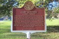 view gallery view galleryE23.2 km | Cary Mounds - Mississippi Mound Trail - Cary, MS in Mississippi Historical Markers Located at Crab Apple Lane and Willow Lane, Cary posted by: Markerman62 location: Mississippi date approved: 12/06/2020 last visited: 12/16/2020 |
 view gallery view gallery SE23.3 km SE23.3 km
| Hill's Plantation - Onward, MS in Mississippi Historical Markers Part of the Steel's Bayou Expedition, the marker is located on Route 1 about 1/2 mile West of US 61 in Onward. posted by: kwashnak location: Mississippi date approved: 05/28/2013 last visited: never |
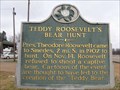 view gallery view galleryE24.1 km | Teddy Roosevelt's Bear Hunt in Mississippi Historical Markers A marker in Onward, MS near the hunting grounds of the famous "Teddy Bear" incident. posted by: iJEEP location: Mississippi date approved: 01/18/2010 last visited: 11/18/2020 |
 view gallery view galleryS26.1 km | Roosevelt in Louisiana Historical Markers This historical marker is located along U.S. Highway 65 in the small community of Roosevelt, Louisiana. posted by: Marine Biologist location: Louisiana date approved: 04/04/2010 last visited: 10/17/2015 |
 view gallery view gallery SW28.2 km SW28.2 km
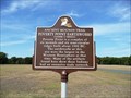
|  Louisiana's Poverty Point earthworks named a UNESCO world heritage site -- near Pioneer LA Louisiana's Poverty Point earthworks named a UNESCO world heritage site -- near Pioneer LA
in News Article Locations When Louisiana's Poverty Point State Historic Site was named a World Heritage Site, it made not just national, but INTERNATIONAL news. posted by: Benchmark Blasterz location: Louisiana date approved: 09/13/2014 last visited: 07/03/2017 |
 view gallery view gallerySW28.2 km |  Monumental Earthworks of Poverty Point -- nr Pioneer LA Monumental Earthworks of Poverty Point -- nr Pioneer LA
in New World Ancient Evidence Native people have been living at Poverty Point for 3000 years. Poverty Point was named the 22nd World Heritage Site in the US by the UNESCO on 22 June 2014. posted by: Benchmark Blasterz location: Louisiana date approved: 09/13/2014 last visited: 07/03/2017 |
 view gallery view gallerySW28.2 km |  Monumental Earthworks of Poverty Point -- nr Pioneer LA Monumental Earthworks of Poverty Point -- nr Pioneer LA
in World Heritage Sites Poverty Point was named a UNESCO World Heritage Site on 22 Jun 2014. When Blasters were there in Aug 2014, the plaque had not arrived yet. posted by: Benchmark Blasterz location: Louisiana date approved: 09/14/2014 last visited: 07/03/2017 |
 view gallery view gallerySW28.3 km | Poverty Point Earthworks: Ancient Mounds Trail in Louisiana Historical Markers Marker on LA 577 just North of entrance to Poverty Point visitor's Center. posted by: kwashnak location: Louisiana date approved: 11/14/2010 last visited: 07/03/2017 |
 view gallery view gallerySW29.6 km | Poverty Point National Monument - Delhi, LA in Louisiana Historical Markers Located at the intersection of Hwy 577 and 134 in Epps LA posted by: nomadwillie location: Louisiana date approved: 12/20/2009 last visited: 07/03/2017 |
 view gallery view gallerySW29.6 km |  Poverty Point Poverty Point
in Wikipedia Entries Located in northeastern Louisiana, Poverty Point commemorates a culture that thrived during the first and second millennia B.C. This site, which contains some of the largest prehistoric earth works in North America. posted by: nomadwillie location: Louisiana date approved: 12/17/2009 last visited: 07/03/2017 |
 view gallery view gallerySW29.6 km |  Poverty Point National Monument - Delhi, LA Poverty Point National Monument - Delhi, LA
in U.S. National Register of Historic Places Located in northeastern Louisiana, Poverty Point commemorates a culture that thrived during the first and second millennia B.C. This site, which contains some of the largest prehistoric earth works in North America. posted by: nomadwillie location: Louisiana date approved: 06/25/2009 last visited: 07/03/2017 |
 view gallery view galleryN29.6 km |  Geodesic Dome on Home - Eudora, AR Geodesic Dome on Home - Eudora, AR
in Geodesic Domes A private geodesic dome attached to a home located in Eudora, Arkansas, USA. posted by: Marine Biologist location: Arkansas date approved: 04/18/2010 last visited: never |
|