 view gallery view gallery N0.3 km N0.3 km
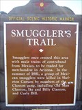
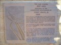
|   Smugglers’ Trail Smugglers’ Trail
in New Mexico Historical Markers Look at both sides of this New Mexico OSHM. The Clayton Hideout is on the other side. posted by:  leadhiker leadhiker location: New Mexico date approved: 06/16/2011 last visited: 11/04/2014 |
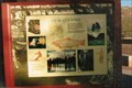
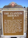 view gallery view galleryN0.3 km | The Clanton Hideout in New Mexico Historical Markers This New Mexico OSHM has another marker on the other side. posted by: leadhiker location: New Mexico date approved: 06/15/2011 last visited: 11/04/2014 |
 view gallery view gallery E10.5 km E10.5 km
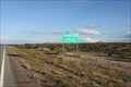
|  Continental Divide NM Hwy 9, New Mexico Continental Divide NM Hwy 9, New Mexico
in Elevation Signs Continental Divide Elevation Sign on Hwy 9, New Mexico posted by:  outwest63 outwest63 location: New Mexico date approved: 01/21/2015 last visited: 06/09/2018 |
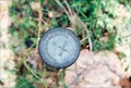
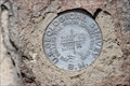
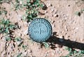 view gallery view galleryE15.4 km |  1914 Section Mark 1914 Section Mark
in U.S. Benchmarks 1914 Section mark for Sections 23 and 24 posted by: GmannL1 location: New Mexico date approved: 08/22/2008 last visited: never |
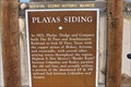 view gallery view galleryE18.2 km | Playas Siding in New Mexico Historical Markers New Mexico Historical Marker on Highway 9 at mile post 25.5 posted by: outwest63 location: New Mexico date approved: 04/17/2011 last visited: 11/03/2010 |
 view gallery view gallery W21.9 km W21.9 km
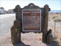
| Rodeo Intermediate Field Civil Aeronautics Authority #57A in New Mexico Historical Markers The Rodeo Intermediate Field Civil Aeronautics Authority Field #57A is located at the intersection of N.M. highways 80 and 9. posted by: outwest63 location: New Mexico date approved: 06/24/2013 last visited: 06/11/2018 |
 view gallery view gallery SW24.6 km SW24.6 km
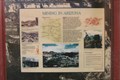
| Rodeo Station in New Mexico Historical Markers Another town whose past history was tied to the railroad, but whose modern history is also fascinating. posted by: linkys location: New Mexico date approved: 12/17/2009 last visited: 06/11/2018 |
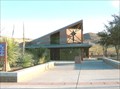
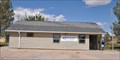 view gallery view gallerySW24.8 km |  Rodeo, New Mexico 88056 Rodeo, New Mexico 88056
in U.S. Post Offices This Post Office is located at 16 Custie Avenue in Rodeo, New Mexico. posted by: brwhiz location: New Mexico date approved: 11/06/2011 last visited: never |
 view gallery view galleryE25.1 km | 1914 Section Marker S22/S23 in U.S. Benchmarks East of road 113 along fence line posted by: GmannL1 location: New Mexico date approved: 08/22/2008 last visited: never |
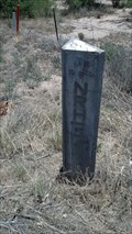 view gallery view gallerySW27.5 km |  Arizona/New Mexico State Boundary Marker - State Route 80 - Arizona Arizona/New Mexico State Boundary Marker - State Route 80 - Arizona
in Public Land Survey Marks A marker along Arizona State Route 80/New Mexico State Road 80 that marks the boundary between Arizona and New Mexico. posted by: adenium location: Arizona date approved: 07/19/2012 last visited: 10/16/2012 |
 view gallery view gallerySW27.5 km |  AZ/NM - Highway 80 AZ/NM - Highway 80
in Border Crossings Border crossing between Arizona and New Mexico on Highway 80. posted by: outwest63 location: Arizona date approved: 04/16/2011 last visited: 09/25/2017 |
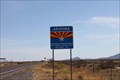
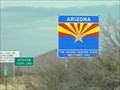
 view gallery view gallerySW27.5 km |  Arizona ~ The Grand Canyon State Arizona ~ The Grand Canyon State
in Welcome Signs This Welcome Sign greets you when you cross the border from New Mexico on New Mexico/Arizona Highway 80 southwest of Rodeo, New Mexico. posted by: brwhiz location: Arizona date approved: 02/16/2013 last visited: 06/05/2013 |
 view gallery view gallery NW35.2 km NW35.2 km
|  Steins Cemetery - Steins, NM Steins Cemetery - Steins, NM
in Worldwide Cemeteries This small cemetery of perhaps fifty graves is just south of I-10 - in Steins, New Mexico. posted by: The Snowdog location: New Mexico date approved: 05/27/2022 last visited: never |
 view gallery view galleryNW38.5 km | NM-AZ on I-10 in Border Crossings This border crossing between New Mexico and Arizona is on I-10. If you want to take pictures, be prepared to take them 'on the fly'. posted by: PeterNoG location: Arizona date approved: 02/25/2011 last visited: 05/18/2023 |
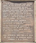 view gallery view gallerySW41.4 km |  Last Apache Chieftain Last Apache Chieftain
in Last of its Kind Geronimo was the last Apache Chieftain to wage war against the white man. posted by: brwhiz location: Arizona date approved: 11/27/2012 last visited: never |
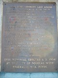 view gallery view gallerySW41.4 km |  Geronimo Surrender Monument Geronimo Surrender Monument
in Arizona Historical Markers On Route 80 south of Rodeo, New Mexico, near Apache, Arizona, stands a marker commemorating Geronimo's surrender. A short distance south of the marker is a road which leads east and then south/southeast to the actual surrender site. posted by: leadhiker location: Arizona date approved: 05/17/2010 last visited: 06/17/2012 |
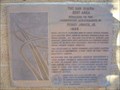 view gallery view galleryNW41.5 km | The San Simon Rest Area in Arizona Historical Markers Dedicated to the
Engineering Achievements of
Percy Jones, Jr. posted by: leadhiker location: Arizona date approved: 06/15/2011 last visited: 02/22/2019 |
 view gallery view galleryNW41.5 km |  Percy Jones, Jr. - The San Simon Rest Area, Arizona Percy Jones, Jr. - The San Simon Rest Area, Arizona
in Citizen Memorials Dedicated to the Engineering Achievements of Percy Jones, Jr. posted by: YoSam. location: Arizona date approved: 02/22/2019 last visited: never |
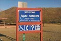
 view gallery view galleryNW41.7 km |  Arizona High Country - San Simon, AZ Arizona High Country - San Simon, AZ
in Flora and Fauna Information Signs Two markers mainly for flora and fauna. posted by: YoSam. location: Arizona date approved: 12/21/2021 last visited: never |
 view gallery view galleryNW41.7 km | Mining In Arizona - San Simon Rest Area, San Simon, AZ in Arizona Historical Markers Instructional - historical markers in the rest area. posted by: YoSam. location: Arizona date approved: 07/20/2016 last visited: 12/28/2018 |
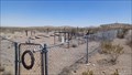
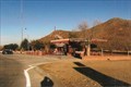
 view gallery view galleryNW41.7 km |  San Simon Rest Area, San Simon, AZ San Simon Rest Area, San Simon, AZ
in Highway Rest Areas First rest area on I-10 as you enter Arizona from New Mexico. posted by: YoSam. location: Arizona date approved: 03/22/2009 last visited: 06/03/2018 |
 view gallery view galleryNW41.7 km |  San Simon Rest Area, San Simon, AZ San Simon Rest Area, San Simon, AZ
in Free Overnight RV Parking Locations First rest area on I-10 as you enter Arizona from New Mexico. posted by: YoSam. location: Arizona date approved: 02/22/2019 last visited: 01/12/2020 |
 view gallery view galleryNW41.7 km |  San Simon rest areas reopen on I-10 in southeastern Arizona San Simon rest areas reopen on I-10 in southeastern Arizona
in News Article Locations Westbound side posted by: YoSam. location: Arizona date approved: 02/22/2019 last visited: never |
 view gallery view galleryW44.3 km | Buena Vista Peak USGS BM - Cochise County, Az. in U.S. Benchmarks The disk is located on the site of the remains of the Barfoot Look Out Tower on Buena Vista Peak. Buena Vista Peak is located in the Chiricahua Mountains in South Eastern Arizona. posted by: outwest63 location: Arizona date approved: 06/21/2013 last visited: 05/27/2023 |
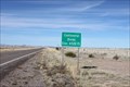 view gallery view galleryE44.6 km | Continental Divide Hwy. 146, New Mexico in Elevation Signs Continental Divide marker on Hwy. 9 in New Mexico. posted by: outwest63 location: New Mexico date approved: 01/21/2015 last visited: never |
|