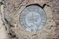
 view gallery view gallery S6.6 km S6.6 km
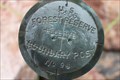
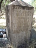
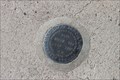
|   US Forest Reserve Boundry Marker No. 96 US Forest Reserve Boundry Marker No. 96
in Public Land Survey Marks The Boundry marker is located South East of the Forestry Camp in Rucker Canyon posted by:  outwest63 outwest63 location: Arizona date approved: 11/02/2013 last visited: never |
 view gallery view gallery SE6.9 km SE6.9 km
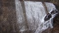
|  Falls at Rucker Lake Falls at Rucker Lake
in Man-made Waterfalls Roper Lake was filled in from debris caused by the Rattlesnake Fire in the late 1992. The stream now flows over the Dam. posted by: outwest63 location: Arizona date approved: 11/03/2010 last visited: 05/15/2010 |
 view gallery view gallery NW7.4 km NW7.4 km
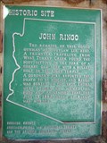
|  John Ringo John Ringo
in Arizona Historical Markers For more than a century, mystery and controversy have circulated about the details of Ringo's demise, making his death one of the most hotly debated deaths in Old West history.
This site is on private property. Please obey all signs. posted by:  leadhiker leadhiker location: Arizona date approved: 05/17/2010 last visited: 04/22/2011 |
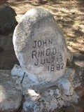 view gallery view galleryNW7.4 km |  Johnny Ringo - Wild West Gunman Johnny Ringo - Wild West Gunman
in Grave of a Famous Person A solitary gravesite on a private ranch in Southeastern Arizona; buried where he was found dead. The life of Johnny Ringo has taken on almost mythical status in the lore of the American Wild West. Open to the public from 8AM - 6PM. posted by: Scrawlinn location: Arizona date approved: 08/31/2008 last visited: 04/22/2011 |
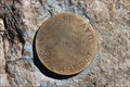 view gallery view gallery NE12.2 km NE12.2 km
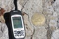
|  Barfoot Helo Spot Barfoot Helo Spot
in U.S. Benchmarks Inscription on brass cap reads: ASA 2205 BARFOOT UAV 1994 posted by: outwest63 location: Arizona date approved: 10/07/2013 last visited: never |
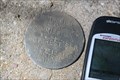 view gallery view gallery N12.6 km N12.6 km
| Pinery Canyon Methodist Camp Control Point in U.S. Benchmarks This survey marker is stamped with the following: Methodist Camp Commission US Forest Ser Oct 12 1963 Control Point. posted by: outwest63 location: Arizona date approved: 10/07/2013 last visited: never |
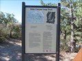
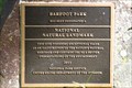 view gallery view galleryNE12.9 km |  Barfoot Park, Az. Barfoot Park, Az.
in U.S. National Natural Landmarks Barfoot Park is located in the Chirichua Mountains of South East Arizona. posted by: outwest63 location: Arizona date approved: 01/22/2012 last visited: 09/23/2013 |
 view gallery view galleryNE13 km | Buena Vista Peak USGS BM - Cochise County, Az. in U.S. Benchmarks The disk is located on the site of the remains of the Barfoot Look Out Tower on Buena Vista Peak. Buena Vista Peak is located in the Chiricahua Mountains in South Eastern Arizona. posted by: outwest63 location: Arizona date approved: 06/21/2013 last visited: 05/27/2023 |
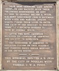
 view gallery view galleryN15.1 km |  CCC Grave Marker – Chiricahua Mtns, AZ CCC Grave Marker – Chiricahua Mtns, AZ
in Civilian Conservation Corps A lone gravestone erected by the CCC in 1937. Close to the main road across the northern end of the Chiricahua Mountains. posted by: Scrawlinn location: Arizona date approved: 06/01/2008 last visited: never |
 N15.1 km |  Tom Frendy Grave Tom Frendy Grave
in Abandoned Cemeteries A lone gravesite in Coronado National Forest posted by: albedo60 location: Arizona date approved: 04/14/2007 last visited: 05/30/2008 |
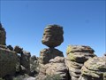 view gallery view galleryN19.3 km |  Big Balanced Rock, Chiricahua National Monument - Cochise County, Arizona Big Balanced Rock, Chiricahua National Monument - Cochise County, Arizona
in Nature's Balanced Rocks A balanced rock in Chiricahua National Monument along the Sarah Deming Trail. posted by: adenium location: Arizona date approved: 07/18/2012 last visited: 04/04/2017 |
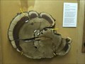 view gallery view galleryN20.1 km |  Tree ring display - Chiricahua National Monument Tree ring display - Chiricahua National Monument
in Exceptional Tree Growth Ring Displays Display about tree growth inside the visitor center. posted by: tnwave location: Arizona date approved: 09/02/2019 last visited: 09/03/2019 |
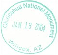 view gallery view galleryN20.1 km |  Chiricahua National Monument Chiricahua National Monument
in NPS Passport Cancellation Stations Visitor center at Chiricahua National Monument. posted by: Team Caballero location: Arizona date approved: 02/17/2009 last visited: 03/05/2023 |
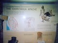 view gallery view galleryN20.1 km | This was the Home of the Chiricahua Apache - Willcox AZ in Arizona Historical Markers This was the homeland of the Chiricahua Apache, Chiricahua National Monument. From out of the north came these semi nomadic hunters. Separating from other Apache groups in the 1690’s, the Chiricahua Apache moved into southeastern Arizona. posted by: Don.Morfe location: Arizona date approved: 11/19/2020 last visited: 10/23/2021 |
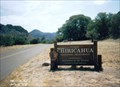
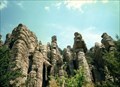
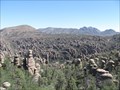 view gallery view galleryN20.3 km | ") Chiricahua National Monument - Arizona Chiricahua National Monument - Arizona
in National Parks (U.S.) This National Monument preserves an area of the Chiricahua Mountains in southern Arizona known for its rock spires and unusual rock formations. posted by: adenium location: Arizona date approved: 06/20/2012 last visited: 02/16/2022 |
 view gallery view galleryN20.3 km |  Chiricahua National Monument - Willcox AZ Chiricahua National Monument - Willcox AZ
in National Parks of the World Chiricahua National Monument is a unit of the National Park System located in the Chiricahua Mountains of southeastern Arizona. The monument was established on April 18, 1924, to protect its extensive hoodoos and balancing rocks. posted by: Don.Morfe location: Arizona date approved: 02/15/2022 last visited: 02/16/2022 |
 view gallery view galleryN20.3 km |  Chiricahua National Monument - Willcox AZ Chiricahua National Monument - Willcox AZ
in Official Local Tourism Attractions Chiricahua National Monument is a unit of the National Park System located in the Chiricahua Mountains of southeastern Arizona. The monument was established on April 18, 1924, to protect its extensive hoodoos and balancing rocks. posted by: Don.Morfe location: Arizona date approved: 02/15/2022 last visited: 02/16/2022 |
 view gallery view galleryN20.3 km |  Chiricahua National Monument - Willcox AZ Chiricahua National Monument - Willcox AZ
in Wikipedia Entries Chiricahua National Monument is a unit of the National Park System located in the Chiricahua Mountains of southeastern Arizona. The monument was established on April 18, 1924, to protect its extensive hoodoos and balancing rocks. posted by: Don.Morfe location: Arizona date approved: 02/15/2022 last visited: 02/16/2022 |
 view gallery view galleryN20.3 km |  Chiricahua National Monument Historic Designed Landscape - Willcox AZ Chiricahua National Monument Historic Designed Landscape - Willcox AZ
in U.S. National Register of Historic Places Chiricahua National Monument is a unit of the National Park System located in the Chiricahua Mountains of southeastern Arizona. The monument was established on April 18, 1924, to protect its extensive hoodoos and balancing rocks. posted by: Don.Morfe location: Arizona date approved: 02/19/2022 last visited: 02/16/2022 |
 view gallery view galleryN20.3 km |  Chiricahua National Monument - Willcox AZ Chiricahua National Monument - Willcox AZ
in Satellite Imagery Oddities Chiricahua National Monument is a unit of the National Park System located in the Chiricahua Mountains of southeastern Arizona. The monument was established on April 18, 1924, to protect its extensive hoodoos and balancing rocks. posted by: Don.Morfe location: Arizona date approved: 02/15/2022 last visited: 02/16/2022 |
 view gallery view galleryN20.6 km | Faraway Ranch in U.S. Benchmarks Bench mark is located in the side walk for the Faraway Ranch homestead. posted by: outwest63 location: Arizona date approved: 10/22/2011 last visited: never |
 view gallery view galleryN21.2 km |  Echo Canyon Trailhead - Chiricahua National Monument - Arizona Echo Canyon Trailhead - Chiricahua National Monument - Arizona
in Hiking and walking trailheads A 2-mile loop trail in Chiricahua National Monument. posted by: adenium location: Arizona date approved: 06/18/2012 last visited: 09/02/2019 |
 view gallery view galleryN22.2 km | 285+40 Bonita Canyon Road in U.S. Benchmarks Marker is located on Bonita Canyon Road in the Chiricahua National monument. posted by: outwest63 location: Arizona date approved: 05/10/2011 last visited: never |
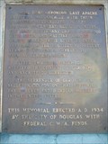
 view gallery view gallerySE25.9 km |  Last Apache Chieftain Last Apache Chieftain
in Last of its Kind Geronimo was the last Apache Chieftain to wage war against the white man. posted by: brwhiz location: Arizona date approved: 11/27/2012 last visited: never |
 view gallery view gallerySE25.9 km | Geronimo Surrender Monument in Arizona Historical Markers On Route 80 south of Rodeo, New Mexico, near Apache, Arizona, stands a marker commemorating Geronimo's surrender. A short distance south of the marker is a road which leads east and then south/southeast to the actual surrender site. posted by: leadhiker location: Arizona date approved: 05/17/2010 last visited: 06/17/2012 |
|