 view gallery view gallery E9.2 km E9.2 km
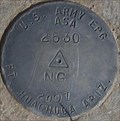
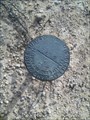
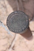
|   ASA 2530 NG 2007 ASA 2530 NG 2007
in U.S. Benchmarks A benchmark place by the U.S.Army in 2007 posted by:  MIG2 MIG2 location: Arizona date approved: 02/19/2012 last visited: never |
 view gallery view gallery SW9.7 km SW9.7 km
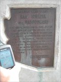
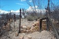
|  San Ignacia del Babocomari San Ignacia del Babocomari
in Arizona Historical Markers I found this gem back in July of 2005 because I'm a big marker fan. What a story! Can you imagine the robbery!!?? I tried to find a website to learn more. No avail. posted by: unimoggers location: Arizona date approved: 09/22/2007 last visited: 12/31/2012 |
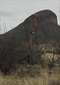 view gallery view gallerySW10.6 km |  Lonely Chimney along Upper Egin Rd.-Arizona Lonely Chimney along Upper Egin Rd.-Arizona
in Lonely Chimneys Spotted this lonely chimney next to the road. posted by: grandmabetsy location: Arizona date approved: 03/12/2018 last visited: never |
 view gallery view gallery NE10.8 km NE10.8 km
|  Kartchner Caverns State Park Penny Smasher Kartchner Caverns State Park Penny Smasher
in Penny Smashers This four-design Penny Smasher is in the Kartchner Caverns State Park Visitor Center at 2950 S Highway 90 south of Benson, Arizona. posted by: brwhiz location: Arizona date approved: 10/22/2011 last visited: 12/06/2014 |
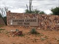 view gallery view galleryNE11.1 km |  Kartchner Caverns State Park - Benson, AZ Kartchner Caverns State Park - Benson, AZ
in State/Provincial Parks Kartchner Caverns State Park in Southeastern Arizona features a stunning and pristine limestone cave with world-class features that have been protected since its discovery in 1974. posted by: Poehunters location: Arizona date approved: 07/17/2013 last visited: 02/05/2018 |
 view gallery view galleryE14.2 km | US General Land Office Survey S22 1/4 S 27 - Cochise County, AZ in U.S. Benchmarks looks to be corner marker posted by: JammieMan location: Arizona date approved: 12/05/2016 last visited: never |
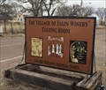 view gallery view gallerySW15.3 km |  The Village of Elgin Winery-Arizona The Village of Elgin Winery-Arizona
in Wineries The Village of Elgin Winery and Tasting Room. posted by: grandmabetsy location: Arizona date approved: 03/12/2018 last visited: 06/18/2021 |
 view gallery view gallery SE17.1 km SE17.1 km
|  HIDEOUT HIDEOUT
in Public Land Survey Marks This is a Cochies county highway and flood marker. posted by:  rzrnator rzrnator location: Arizona date approved: 03/07/2012 last visited: 08/18/2013 |
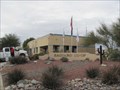
 view gallery view gallerySE20.1 km | Fort Huachuca (1877) in Arizona Historical Markers Fort Huachuca, constructed in 1877, was one of a chain of forts established to guard southern Arizona against the Chiricahua Apaches, led by Geronimo. posted by: leadhiker location: Arizona date approved: 05/10/2010 last visited: 07/08/2018 |
 view gallery view galleryE21.7 km | S32-S33 T19S R21E New Balance Road in Public Land Survey Marks The brass cap is located on the East side of the road next to a fence post. posted by: outwest63 location: Arizona date approved: 07/16/2012 last visited: never |
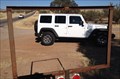 view gallery view gallery W22 km W22 km
|  Get Framed Get Framed
in Framed Views Put yourself in the frame or just the view from that spot.. posted by: grandmabetsy location: Arizona date approved: 12/27/2013 last visited: 12/27/2013 |
 view gallery view galleryW22 km |  Blackberry Picking at Harris Heritage Growers, Sonoita, AZ Blackberry Picking at Harris Heritage Growers, Sonoita, AZ
in Berry Picking Pick your own Blueberries from early July to late September at Harris Heritage Growers in Sonoita, AZ. posted by: Poehunters location: Arizona date approved: 08/14/2013 last visited: 06/20/2021 |
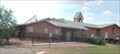
 view gallery view galleryNE22.5 km |  Covered wagon, Benson, AZ Covered wagon, Benson, AZ
in Covered Wagons A covered wagon in Benson, AZ posted by: TucsonThompsen location: Arizona date approved: 06/04/2010 last visited: 07/12/2013 |
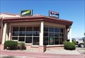
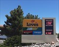 view gallery view galleryNE22.5 km |  Love's Travel Center - Benson, AZ Love's Travel Center - Benson, AZ
in Truck Stops This Love's Travel Center is on Highway 90, just south of I-10, in Benson, Arizona. posted by: The Snowdog location: Arizona date approved: 01/05/2021 last visited: 06/18/2021 |
 view gallery view galleryNE22.5 km |  McDonalds Free WiFi ~ Benson, Arizona McDonalds Free WiFi ~ Benson, Arizona
in Wi-Fi Hotspots Free WiFi Served Daily at the McDonalds at 618 S Arizona Highway 90 in Benson, Arizona. posted by: brwhiz location: Arizona date approved: 11/24/2012 last visited: 08/15/2017 |
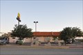
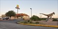 view gallery view galleryNE22.5 km |  McDonalds ~ Benson, Arizona McDonalds ~ Benson, Arizona
in McDonald's Restaurants This McDonalds is located at 618 S Arizona Highway 90 in Benson, Arizona. posted by: brwhiz location: Arizona date approved: 12/01/2012 last visited: 08/15/2017 |
 view gallery view galleryNE22.5 km |  Subway - Benson, AZ Subway - Benson, AZ
in Subway Restaurants This Subway shares a space with Chester's and Godfather's at a Love's Travel Stop - on Highway 90 at I-10 in Benson, Arizona. posted by: The Snowdog location: Arizona date approved: 01/05/2021 last visited: never |
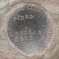 view gallery view galleryNE23.2 km | PEDRO LS303.65 2005 COCHISE COUNTY in U.S. Benchmarks A benchmark listed in the NGS database, but not the GC.com database. posted by: MIG2 location: Arizona date approved: 02/24/2012 last visited: never |
 view gallery view galleryNE23.3 km |  SKP RV PARK - Benson, AZ SKP RV PARK - Benson, AZ
in Bookcrossing Zones Book release site at an RV park for retirees who travel to Arizona for the warm temperatures in the winter. posted by: linkys location: Arizona date approved: 01/03/2010 last visited: 11/28/2014 |
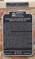 view gallery view gallerySW23.3 km | Sonoita Quarter Horse Show and Races in Arizona Historical Markers One of four American Quarter Horse Heritage Center & Museum Markers in Arizona. posted by: leadhiker location: Arizona date approved: 11/21/2011 last visited: never |
 view gallery view galleryNE23.3 km |  Apache Powder Company- St. David, AZ Apache Powder Company- St. David, AZ
in Super Fund Sites Site of an operation manufacturing industrial chemicals and explosives which resulted in soil and groundwater contamination. posted by: linkys location: Arizona date approved: 01/03/2010 last visited: 09/02/2019 |
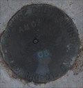 view gallery view galleryNE23.3 km | AMOX DK7527 COCHISE COUNTY HIGHWAY AND FLOODPLAN DEPT. LS36365 2005 in U.S. Benchmarks This is a floodplan survey mark. posted by: MIG2 location: Arizona date approved: 02/19/2012 last visited: never |
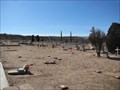
 view gallery view galleryE23.8 km |  Fairbank Townsite Fairbank Townsite
in Abandoned Cemeteries Fairbank is an abandoned"ghost" town located along the San Pedro river off State Highway 82 west of Tombstone, AZ posted by: beagle39z location: Arizona date approved: 03/28/2007 last visited: 01/25/2004 |
 view gallery view galleryW24 km |  Santa Rita Abbey - Sonoita, Arizona (near Tucson) Santa Rita Abbey - Sonoita, Arizona (near Tucson)
in Abbeys, Convents and Monasteries Santa Rita Abbey south of Tucson, Arizona. Please visit their website. posted by: unimoggers location: Arizona date approved: 08/03/2007 last visited: 06/15/2008 |
 view gallery view galleryNE24.1 km |  High Street Cemetery - Benson, AZ High Street Cemetery - Benson, AZ
in Eagle Scout Project Sites Manuel Santiago's Eagle Project involved researching the old records and then adding markers to unmarked graves at the High Street Cemetery in Benson, Arizona. posted by: linkys location: Arizona date approved: 01/02/2010 last visited: 12/20/2019 |
|