 view gallery view gallery N96.4 km N96.4 km
|   International Boundary and Water Commission International Boundary and Water Commission
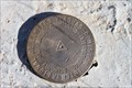
in U.S. Benchmarks This marker is located on a hill approximately 200 feet north of the border between Mexico and the United States in Santa Cruz County, Arizona. posted by:  outwest63 outwest63 location: Arizona date approved: 01/17/2011 last visited: never |
 view gallery view galleryN96.6 km |  Lochiel Schoolhouse, Santa Cruz County, AZ Lochiel Schoolhouse, Santa Cruz County, AZ
in One-Room Schoolhouses One room adobe schoolhouse in southern Arizona near the Mexican border. posted by: tugies location: Arizona date approved: 10/17/2014 last visited: 12/31/2014 |
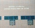 view gallery view galleryN98.3 km |  United States/Mexico on W. International Street - Nogales AZ United States/Mexico on W. International Street - Nogales AZ
in Border Crossings The Border Crossing in Nogales AZ is between the United States and Mexico. The crossing is on W. International Street near the end of Interstate I-19. posted by:  Don.Morfe Don.Morfe location: Arizona date approved: 04/25/2022 last visited: 04/23/2022 |
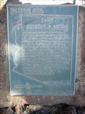
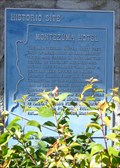 view gallery view galleryN98.3 km |  Montezuma Hotel Montezuma Hotel
in Arizona Historical Markers The Montezuma Hotel, built in 1886, rebuilt twice, and closed in 1965, was the center of Nogales business and social life for more than half a century. posted by: leadhiker location: Arizona date approved: 05/04/2010 last visited: never |
 view gallery view galleryN99.5 km | Camp Stephen D. Little in Arizona Historical Markers In late 1910, the U.S. Army established a permanent camp (later dedicated to fallen soldier Stephen D. Little) in Nogales, Arizona. posted by: leadhiker location: Arizona date approved: 06/25/2011 last visited: never |
 view gallery view galleryN99.8 km | Grand Ave - Frank Reed School in Arizona Historical Markers Grand Ave. School was founded in 1928 as a grammar school, grades one through eight, for the African American children of Nogales. posted by: leadhiker location: Arizona date approved: 05/04/2010 last visited: never |
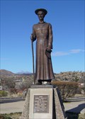 view gallery view galleryN99.9 km |  Padre Eusebio Francisco Kino SJ - Nogales, AZ Padre Eusebio Francisco Kino SJ - Nogales, AZ
in Statues of Historic Figures Earliest pioneer of civilization in the southwest heroic missionary to the Pima Indians intrepid explorer founder of San Xavier del Bac. posted by: leadhiker location: Arizona date approved: 05/04/2010 last visited: 06/30/2018 |
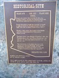
 view gallery view galleryN102.2 km | Santa Cruz County LIDAR #9 in U.S. Benchmarks Santa Cruz County Flood Control District flood map modernization project LIDAR Mapping Checkpoint #9. posted by: Arizona Ranger Team location: Arizona date approved: 03/22/2011 last visited: never |
 view gallery view gallery NE106.4 km NE106.4 km
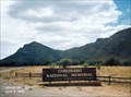
|  Coronado National Memorial - Hereford AZ Coronado National Memorial - Hereford AZ
in Wikipedia Entries The Coronado National Memorial commemorates the first organized expedition into the Southwest by conquistador Francisco Vásquez de Coronado in 1540. posted by: Don.Morfe location: Arizona date approved: 02/15/2022 last visited: 02/16/2022 |
 view gallery view galleryNE106.9 km |  Coronado National Memorial - Hereford AZ Coronado National Memorial - Hereford AZ
in U.S. National Register of Historic Places Coronado National Monument was established in 1952 to commemorate the first major Spanish exploration into the American Southwest, the Francisco Vasquez de Coronado expedition of 1540-42. posted by: Don.Morfe location: Arizona date approved: 02/19/2022 last visited: 02/16/2022 |
 view gallery view galleryNE106.9 km | ") Coronado National Monument - Hereford AZ Coronado National Monument - Hereford AZ
in National Parks (U.S.) Coronado National Monument was established in 1952 to commemorate the first major Spanish exploration into the American Southwest, the Francisco Vasquez de Coronado expedition of 1540-42. posted by: Don.Morfe location: Arizona date approved: 11/20/2020 last visited: 02/16/2022 |
 view gallery view galleryNE106.9 km |  Coronado National Monument - Hereford AZ Coronado National Monument - Hereford AZ
in National Parks of the World Coronado National Monument was established in 1952 to commemorate the first major Spanish exploration into the American Southwest, the Francisco Vasquez de Coronado expedition of 1540-42. posted by: Don.Morfe location: Arizona date approved: 02/15/2022 last visited: 02/16/2022 |
 view gallery view galleryNE106.9 km |  Coronado National Monument - Hereford AZ Coronado National Monument - Hereford AZ
in Official Local Tourism Attractions Coronado National Monument was established in 1952 to commemorate the first major Spanish exploration into the American Southwest, the Francisco Vasquez de Coronado expedition of 1540-42. posted by: Don.Morfe location: Arizona date approved: 02/15/2022 last visited: 02/16/2022 |
 view gallery view galleryNE106.9 km |  Coronado National Monument - Hereford AZ Coronado National Monument - Hereford AZ
in Satellite Imagery Oddities Coronado National Monument was established in 1952 to commemorate the first major Spanish exploration into the American Southwest, the Francisco Vasquez de Coronado expedition of 1540-42. posted by: Don.Morfe location: Arizona date approved: 02/15/2022 last visited: 02/16/2022 |
 view gallery view galleryNE106.9 km |  Coronado National Memorial Coronado National Memorial
in NPS Passport Cancellation Stations Coronado National Memorial, near Sierra Vista, Arizona, commemorates the first organized expedition into the Southwest by conquistador Francisco Vásquez de Coronado. posted by: leadhiker location: Arizona date approved: 03/10/2010 last visited: 03/05/2023 |
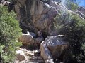 view gallery view galleryNE107.7 km | ") Coronado Cave Coronado Cave
in Cave Entrances (Natural) Small dry cave located in Coronado National Memorial; great cave to introduce others to spelunking.
posted by: Megadrile location: Arizona date approved: 02/17/2008 last visited: 11/30/2017 |
 view gallery view galleryN108.5 km |  Smokey Bear near the Mexican border in southern Arizona Smokey Bear near the Mexican border in southern Arizona
in Smokey Bear Sign Sightings This Smokey Bear is at the junction of Montezuma Canyon and Sunnyside Roads near Parker Canyon lake in SE Arizona. posted by: tugies location: Arizona date approved: 12/14/2013 last visited: 12/25/2013 |
 view gallery view galleryN110.1 km |  Sunnyside Cemetary, Az Sunnyside Cemetary, Az
in Abandoned Cemeteries The cemetary was established by the citizens of the nearby ghost town of Sunnyside. posted by: outwest63 location: Arizona date approved: 01/24/2012 last visited: 06/20/2021 |
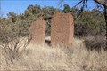 view gallery view galleryN110.9 km |  Harshaw, Az. - Ghost Town Harshaw, Az. - Ghost Town
in Ghost Towns Harshaw is located South of Patagonia, Az. Harshaw was an active mining community from 1877 to 1903. posted by: outwest63 location: Arizona date approved: 10/14/2013 last visited: never |
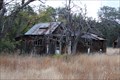 view gallery view galleryN111 km | Sunnyside, Az. in Ghost Towns Sunnyside is a ghost town located on the West side of the Huachuca Mountains in South East Arizona. posted by: outwest63 location: Arizona date approved: 01/23/2012 last visited: 12/12/2013 |
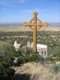 view gallery view galleryNE111 km |  Our Lady of the Sierras Shrine Cross - Hereford, AZ Our Lady of the Sierras Shrine Cross - Hereford, AZ
in Christian Crosses A seventy-five foot Celtic Cross located at the Our Lady of the Sierras Shrine in Hereford, AZ, USA. posted by: HiFiLZ location: Arizona date approved: 05/04/2008 last visited: 04/01/2015 |
 view gallery view galleryNE111.2 km |  Our Lady of the Sierras Shrine Stations of the Cross - Hereford, AZ Our Lady of the Sierras Shrine Stations of the Cross - Hereford, AZ
in Outdoor Stations of the Cross Outdoor Stations of the Cross located on the grounds of the Our Lady of the Sierras Shrine. posted by: HiFiLZ location: Arizona date approved: 05/26/2008 last visited: 07/13/2014 |
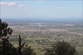 view gallery view galleryN114.6 km |  Sierra Vista, Az. from Carr Canyon Road Sierra Vista, Az. from Carr Canyon Road
in Cityscapes Looking North East from the top of Carr Canyon road. posted by: outwest63 location: Arizona date approved: 11/11/2010 last visited: 04/05/2013 |
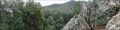 view gallery view galleryN115.6 km |  Brown Canyon Rock Waves Brown Canyon Rock Waves
in Places of Geologic Significance Rocks forming an S-curve next to a waterfall. posted by: Phydux location: Arizona date approved: 04/19/2014 last visited: 05/10/2014 |
 view gallery view galleryN116 km | John Ward's Ranch in Arizona Historical Markers On January 27, 1861, Indians raided John Ward's ranch on Sonoita Creek, abducting Ward's stepson and stealing cattle.
The incident ignited a war that would not be resolved until 1872. posted by: leadhiker location: Arizona date approved: 05/04/2010 last visited: 03/21/2018 |
|