 view gallery view gallery W80.8 km W80.8 km
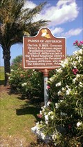
|   Parish of Jefferson - Grand Isle, LA Parish of Jefferson - Grand Isle, LA
in Louisiana Historical Markers Louisiana Historical Marker at the entrance to Grand Isle, Louisiana posted by:  bonsaai bonsaai location: Louisiana date approved: 11/22/2014 last visited: 07/25/2015 |
 view gallery view gallery NW87.2 km NW87.2 km
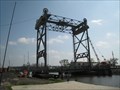
|  Yscloskey Canal bridge Yscloskey Canal bridge
in Vertical Lift Bridges A short vertical lift bridge over a canal. posted by:  flyingmoose flyingmoose location: Louisiana date approved: 03/25/2008 last visited: never |
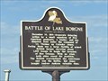 view gallery view galleryNW88.4 km | Battle of Lake Borgne - Saint Bernard, Louisiana in Louisiana Historical Markers Located at the end of Yscloskey Highway next to the Katrina Memorial. posted by: flyingmoose location: Louisiana date approved: 04/12/2021 last visited: never |
 view gallery view galleryNW104.4 km |  Louisiana Highway 23, Naval Air Station /Joint Reserve Base; New Orleans & Belle Chasse, Louisiana Louisiana Highway 23, Naval Air Station /Joint Reserve Base; New Orleans & Belle Chasse, Louisiana
in Blue Star Memorial Highway Markers In front of NAS JRB New Orleans Base posted by: Divecontom location: Louisiana date approved: 02/24/2015 last visited: never |
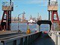
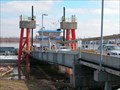 view gallery view galleryNW105.3 km |  Belle Chasse - Scarsdale Ferry, Louisiana Belle Chasse - Scarsdale Ferry, Louisiana
in Ferries and Ferry Landings A ferry on the lower Mississippi River. posted by: no_angel location: Louisiana date approved: 02/01/2008 last visited: never |
 view gallery view galleryNW105.4 km |  Belle Chasse, LA Post Office - 70037 Belle Chasse, LA Post Office - 70037
in U.S. Post Offices This post office is located at 8710 Hwy 23 in Belle Chasse, LA which is in Plaquemines Parish. posted by: VQ9JC location: Louisiana date approved: 08/24/2013 last visited: never |
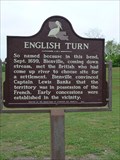 view gallery view galleryNW106.1 km | English Turn in Louisiana Historical Markers A marker commemorating the name of an historic point on the Mississippi River, where French explorer Bienville convinced the English the territory was under French control, therefore causing the English ships to turn around. posted by: no_angel location: Louisiana date approved: 02/22/2012 last visited: 02/21/2012 |
 view gallery view galleryNW106.4 km |  Town of Jean Lafitte, Louisiana Town of Jean Lafitte, Louisiana
in Pirates The Town of Jean Lafitte. posted by: j.r.dalelahey location: Louisiana date approved: 04/18/2015 last visited: never |
 view gallery view galleryNW106.4 km | Town of Jean Lafitte - Jean Lafitte, LA in Louisiana Historical Markers Marker gives brief description of small town in lower Jefferson Parish. Located in front of the local tourist information center. posted by: scrambler390 location: Louisiana date approved: 09/07/2019 last visited: never |
 view gallery view galleryNW106.5 km | Manila Village - Jean Lafitte, LA in Louisiana Historical Markers Gives brief history of area inhabited by Filipinos long ago. posted by: scrambler390 location: Louisiana date approved: 09/07/2019 last visited: never |
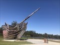 view gallery view galleryNW106.7 km | Pirate Ship Hull - Town of Jean Laffite, LA in Pirates Located in the Town of Jean Laffite, this pirate ship hull stands in a community park. posted by: scrambler390 location: Louisiana date approved: 09/07/2019 last visited: never |
 view gallery view galleryNW107.5 km | Medal of Honor Park - Belle Chasse, Louisiana in Blue Star Memorial Highway Markers Medal of Honor Park in Belle Chasse posted by: Divecontom location: Louisiana date approved: 02/22/2015 last visited: never |
 view gallery view galleryNW107.7 km | Barataria Preserve - Marrero, LA in Louisiana Historical Markers Gives a brief history of a large nature/wetlands preserve. posted by: scrambler390 location: Louisiana date approved: 09/07/2019 last visited: never |
 view gallery view galleryNW108.5 km |  The Meraux water tower. The Meraux water tower.
in Water Towers This tower is located in the town of Meraux, just down from Chalmette, LA.
It is the only one I could find in the area, so It probably is the towns only one.
posted by: Angel&Richie location: Louisiana date approved: 01/21/2009 last visited: 10/29/2010 |
 view gallery view galleryNW110.1 km | Chalmette Ferry in Ferries and Ferry Landings A ferry that connects the east bank and west bank of the Mississippi River just downriver from New Orleans. posted by: no_angel location: Louisiana date approved: 01/14/2008 last visited: 05/01/2010 |
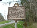 view gallery view galleryNW110.7 km | Barataria Settlement in Louisiana Historical Markers Barataria Settlement historical marker posted by: iCop location: Louisiana date approved: 02/12/2008 last visited: never |
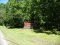 view gallery view galleryNW110.9 km |  Barataria Unit of Jean Lafitte Historical Park Historic District - Barataria, LA Barataria Unit of Jean Lafitte Historical Park Historic District - Barataria, LA
in U.S. National Register of Historic Places The Barataria Preserve outside Marrero offers a taste of Louisiana’s wild wetlands. The preserve’s 20,000 acres include bayous, swamps, marshes, forests, alligators, nutrias, and over 300 species of birds. posted by: nomadwillie location: Louisiana date approved: 06/23/2009 last visited: 05/08/2022 |
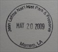 view gallery view galleryNW110.9 km |  Jean Lafitte NHP and Preserve - Barataria Preserve - Marrero LA Jean Lafitte NHP and Preserve - Barataria Preserve - Marrero LA
in NPS Passport Cancellation Stations The stamp can be found at the Visitor Center at Barataria Preserve. Don't forget to walk the boardwalk into the bayou. posted by: nomadwillie location: Louisiana date approved: 07/10/2009 last visited: 05/08/2022 |
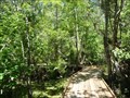 view gallery view galleryNW110.9 km |  Barataria Unit of Jean Lafitte Historical Park Historic District - Barataria, LA Barataria Unit of Jean Lafitte Historical Park Historic District - Barataria, LA
in Non-Coastal Boardwalks The Barataria Preserve outside Marrero offers a taste of Louisiana’s wild wetlands. The preserve’s 20,000 acres include bayous, swamps, marshes, forests, alligators, nutrias, and over 300 species of birds. posted by: nomadwillie location: Louisiana date approved: 06/29/2009 last visited: 05/08/2022 |
 view gallery view galleryNW110.9 km |  Jean Lafitte National Historical Park and Preserve Jean Lafitte National Historical Park and Preserve
in Wikipedia Entries Jean Lafitte National Historical Park and Preserve protects significant examples of the rich natural and cultural resources of Louisiana's Mississippi River Delta region. posted by: nomadwillie location: Louisiana date approved: 12/18/2009 last visited: 05/08/2022 |
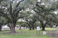
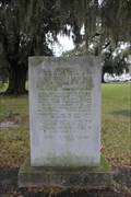 view gallery view galleryNW111.4 km | The Versailles Oaks -- Chalmette LA in Louisiana Historical Markers Across the Louisiana State Highway 46 stand the Versailles Oaks, a living remnant of Pierre De La Ronde's magnificent plantation, still stand tall, almost 230 years after they were first planted. posted by: Benchmark Blasterz location: Louisiana date approved: 11/24/2017 last visited: 12/29/2014 |
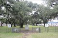 view gallery view galleryNW111.4 km |  The Versailles Oaks -- Chalmette LA The Versailles Oaks -- Chalmette LA
in Historic Trees Local planter Pierre De La Ronde's planted these oaks to give a dramatic entrance to his home. De la Ronde served on General Jackson's staff during the War of 1812. His men camped under these oaks in 1814. posted by: Benchmark Blasterz location: Louisiana date approved: 02/15/2015 last visited: 02/04/2017 |
 view gallery view galleryNW111.4 km |  The Versailles Oaks -- Chalmette LA The Versailles Oaks -- Chalmette LA
in War of 1812 Local planter Pierre De La Ronde's planted these oaks to give a dramatic entrance to his home. De la Ronde served on General Jackson's staff during the War of 1812. His men camped under these oaks in 1814. posted by: Benchmark Blasterz location: Louisiana date approved: 02/16/2015 last visited: 02/03/2017 |
 view gallery view galleryNW111.4 km | Plantation of Pierre Denis De La Ronde -- Chalmette, LA in Louisiana Historical Markers A historic marker near a well-maintained set of the ruins of the de La Ronde plantation, incongruously preserved the middle of a highway median in Chalmette LA posted by: Benchmark Blasterz location: Louisiana date approved: 02/14/2015 last visited: 12/29/2014 |
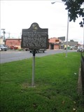 view gallery view galleryNW111.4 km | The Chalmette Plantations in Louisiana Historical Markers In the middle of a road sits the ruins of the Chalmette Plantations and is at the approximate location of the War of 1812 Battle of New Orleans. posted by: NorStar location: Louisiana date approved: 12/15/2007 last visited: 12/29/2014 |
|