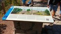
 view gallery view gallery SW0.2 km SW0.2 km
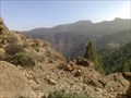
|   Parque rural del Nublo - Tejeda, Gran Canaria, España Parque rural del Nublo - Tejeda, Gran Canaria, España
in Public Access Lands The Nublo rural Park is the largest natural area in Gran Canaria. posted by:  Windschattenwanderer Windschattenwanderer location: Islas Canarias, Spain date approved: 05/21/2019 last visited: 03/09/2023 |
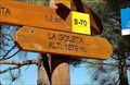 view gallery view gallerySW0.2 km |  La Goleta - La Goleta, Gran Canaria, España. 1579 m La Goleta - La Goleta, Gran Canaria, España. 1579 m
in Elevation Signs Elevation sign at the start of the Ruque Nublo trail. posted by: Windschattenwanderer location: Islas Canarias, Spain date approved: 02/20/2019 last visited: 08/06/2019 |
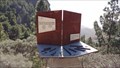
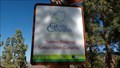 view gallery view gallerySW0.2 km |  Reserva de la Biosfera de Gran Canaria - Islas Canarias, España Reserva de la Biosfera de Gran Canaria - Islas Canarias, España
in UNESCO Geoparks and Biosphere Reserves The island Gran Canaria was declared a UNESCO Biosphere Reserve on 29 June 2005. posted by: Windschattenwanderer location: Islas Canarias, Spain date approved: 02/07/2019 last visited: 08/06/2019 |
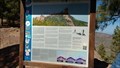
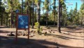
 view gallery view gallerySW0.2 km |  Flora y Fauna de la cumbre de Gran Canaria - La Goleta, Gran Canaria, España Flora y Fauna de la cumbre de Gran Canaria - La Goleta, Gran Canaria, España
in Flora and Fauna Information Signs Information sign about the flora and fauna in the area around the island landmark "Roque Nublo". posted by: Windschattenwanderer location: Islas Canarias, Spain date approved: 02/08/2019 last visited: 08/06/2019 |
 view gallery view gallerySW0.2 km |  Reloj de sol en el sendero del Roque Nublo - La Goleta, Gran Canaria, España Reloj de sol en el sendero del Roque Nublo - La Goleta, Gran Canaria, España
in Sundials Artistic sundial at the start of the Roque Nublo trail. posted by: Windschattenwanderer location: Islas Canarias, Spain date approved: 02/10/2019 last visited: 08/06/2019 |
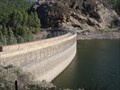 view gallery view gallery E0.5 km E0.5 km
|  Presa de Los Hornos - San Bartolomé de Tirajana, , Gran Canaria, España Presa de Los Hornos - San Bartolomé de Tirajana, , Gran Canaria, España
in Water Dams Water dam in the centre of the island of gran canaria posted by: Windschattenwanderer location: Islas Canarias, Spain date approved: 01/31/2019 last visited: 02/15/2022 |
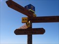 view gallery view gallery W1 km W1 km
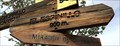
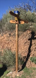
|  Señalización justo antes de Roque Nublo - La Goleta, Gran Canaria, España Señalización justo antes de Roque Nublo - La Goleta, Gran Canaria, España
in Direction and Distance Arrows Signpost just before Roque Nublo posted by: Windschattenwanderer location: Islas Canarias, Spain date approved: 02/25/2019 last visited: 03/09/2023 |
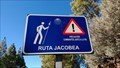 view gallery view galleryE1.3 km |  Signo de Ruta Jacobea - San Bartolomé de Tirajana, Gran Canaria, España Signo de Ruta Jacobea - San Bartolomé de Tirajana, Gran Canaria, España
in Way of St. James Way of St. James road sign on the island of Gran Canaria posted by: Windschattenwanderer location: Islas Canarias, Spain date approved: 02/07/2019 last visited: never |
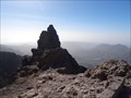
 view gallery view galleryW1.3 km |  Roque Nublo - Gran Canaria, Spain Roque Nublo - Gran Canaria, Spain
in Mountain Summits A one hour climb at Roque Nublo (Spanish meaning the "Rock Clouded"). posted by: MoVeD location: Islas Canarias, Spain date approved: 11/26/2013 last visited: 03/09/2023 |
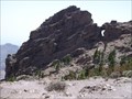
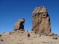 view gallery view galleryW1.3 km |  Roque Nublo - La Goleta, Gran Canaria, España Roque Nublo - La Goleta, Gran Canaria, España
in Established Rock Climbing Areas Climbing on the landmark of the island of Gran Canaria. posted by: Windschattenwanderer location: Islas Canarias, Spain date approved: 02/06/2019 last visited: 03/09/2023 |
 view gallery view galleryE2.7 km | Pico de Las Nieves, Las Palmas - Gran Canaria - Islas Canarias - Spain. 1940 m. in Elevation Signs This sign is located on the road to Pic de las Nieves, ten metres below the summit, at the junction of the S37 and S20 hiking trails. posted by: franketmuriel location: Islas Canarias, Spain date approved: 01/04/2022 last visited: 09/26/2022 |
 view gallery view galleryE2.9 km |  Pico de las Nieves - Vega de San Mateo, Gran Canaria, España Pico de las Nieves - Vega de San Mateo, Gran Canaria, España
in Vértices Geodésicos Vértice Geodésico Pico de las Nieves - 1995,9 m posted by: Windschattenwanderer location: Islas Canarias, Spain date approved: 02/10/2019 last visited: 09/26/2022 |
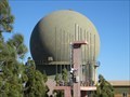 view gallery view galleryE2.9 km |  Cúpula de radar en el Pico de las Nieves - Vega de San Mateo, Gran Canaria, España Cúpula de radar en el Pico de las Nieves - Vega de San Mateo, Gran Canaria, España
in Geodesic Domes Geodesic dome on the military grounds on the Pico de las Nieves. posted by: Windschattenwanderer location: Islas Canarias, Spain date approved: 02/12/2019 last visited: 02/15/2022 |
 view gallery view galleryE2.9 km | Morro de la Agujereada (1956m) - Vega de San Mateo, Gran Canaria, España in Mountain Summits Morro de la Agujereada - the highest mountain on the island of Gran Canaria with a height of 1956 meters. posted by: Windschattenwanderer location: Islas Canarias, Spain date approved: 02/19/2019 last visited: never |
 view gallery view galleryE2.9 km |  Pico de las Nieves (1949 m) Pico de las Nieves (1949 m)
in Geographic High Points Pico de las Nieves, highest point Gran Canaria (1949 m) posted by:  DosHermanas DosHermanas location: Islas Canarias, Spain date approved: 08/14/2011 last visited: 09/26/2022 |
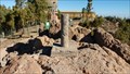
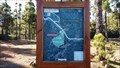
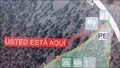 view gallery view galleryE3.1 km |  Usted está aquí - Parque de RV Altos del Pozo - Vega de San Mateo, Gran Canaria, España Usted está aquí - Parque de RV Altos del Pozo - Vega de San Mateo, Gran Canaria, España
in 'You Are Here' Maps You are here map on the camping areal Altos del Pozo posted by: Windschattenwanderer location: Islas Canarias, Spain date approved: 02/09/2019 last visited: never |
 view gallery view galleryE3.1 km |  Parque de RV Altos del Pozo - Vega de San Mateo, Gran Canaria, España Parque de RV Altos del Pozo - Vega de San Mateo, Gran Canaria, España
in Free Overnight RV Parking Locations Small camping area at 1800 meters above sea level. posted by: Windschattenwanderer location: Islas Canarias, Spain date approved: 02/08/2019 last visited: never |
 view gallery view galleryE3.1 km |  Altos del Pozo - Vega de San Mateo, Gran Canaria, España Altos del Pozo - Vega de San Mateo, Gran Canaria, España
in Free Campsites Small camping area at 1800 meters above sea level. posted by: Windschattenwanderer location: Islas Canarias, Spain date approved: 02/09/2019 last visited: never |
 view gallery view gallery NE4 km NE4 km
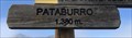
| Pataburro. Cruz de Tejeda - Gran Canaria. 1380 m. in Elevation Signs Esta señal de elevación se encuentra en el sendero S-16 en Pataburro.
This elevation sign is located on the S-16 path at Pataburro. posted by: franketmuriel location: Islas Canarias, Spain date approved: 01/07/2022 last visited: never |
 view gallery view gallery N4.5 km N4.5 km
| Cruz de Tejera, Gran Canaria - Islas Canarias - Spain . 1515 m. in Elevation Signs Esta señal de elevación se encuentra en el inicio de los senderos S-10 y S-90 en Cruz de Tejera.
This elevation sign is located at the start of the S-10 and S-90 trails in Cruz de Tejera. posted by: franketmuriel location: Islas Canarias, Spain date approved: 01/08/2022 last visited: never |
 view gallery view gallery NW5.1 km NW5.1 km
| El Espinillo - Las Palmas, Gran Canaria. 900m in Elevation Signs Esta señal de elevación se encuentra en el sendero S80.
This elevation sign is located on the S80 trail. posted by: franketmuriel location: Islas Canarias, Spain date approved: 04/11/2022 last visited: never |
 view gallery view gallery SE5.3 km SE5.3 km
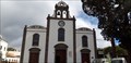
|  Iglesia de San Bartolomé de Tirajana - Tunte, Las Palmas, España Iglesia de San Bartolomé de Tirajana - Tunte, Las Palmas, España
in This Old Church Es una de las joyas del mudéjar canario, se empezó a construer en 1680 // It is one of the jewels of the Canarian Mudejar, construction began in 1680 posted by: xeocach location: Islas Canarias, Spain date approved: 02/06/2023 last visited: never |
 view gallery view gallerySE5.3 km | Iglesia de San Bartolomé de Tirajana - Tunte, Las Palmas, España in Roman Catholic Churches Es una de las joyas del mudéjar canario, se empezó a construer en 1680 // It is one of the jewels of the Canarian Mudejar, construction began in 1680 posted by: xeocach location: Islas Canarias, Spain date approved: 02/06/2023 last visited: never |
 view gallery view galleryN5.5 km | Señalización sendero S90 (DGDA. Los Palomas), Gran Canaria. in Direction and Distance Arrows Esta señal se encuentra en Degollada Los Palomas en el sendero S-90. This sign is located at Degollada Los Palomas on the S-90 path. posted by: franketmuriel location: Islas Canarias, Spain date approved: 01/14/2022 last visited: never |
 view gallery view galleryN5.5 km | DGDA. Las Palomas, Las Palmas - Gran Canaria. 1622m in Elevation Signs Esta señal de elevación se encuentra en el sendero S-90 en Degollada Los Palomas. This elevation sign is located on the S-16 path at Degollada Los Palomas. posted by: franketmuriel location: Islas Canarias, Spain date approved: 01/07/2022 last visited: never |
|