 view gallery view gallery N0.5 km N0.5 km
|   Conners' Toll Highway Conners' Toll Highway
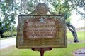
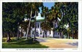
in Florida Historical Markers In Canal Point on US 98. posted by:  Markerman62 Markerman62 location: Florida date approved: 01/27/2015 last visited: 05/26/2021 |
 view gallery view galleryN0.6 km |  US 98/441, Canal Point, FL US 98/441, Canal Point, FL
in Blue Star Memorial Highway Markers Located across from the Canal Point Community Center posted by: Markerman62 location: Florida date approved: 11/13/2018 last visited: 10/29/2018 |
 view gallery view gallery SW5.5 km SW5.5 km
|  Water Tower - Pahokee, Florida Water Tower - Pahokee, Florida
in Water Towers Water tower for the town of Pahokee. posted by: Blue Man location: Florida date approved: 07/27/2014 last visited: 02/07/2016 |
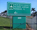 view gallery view gallerySW10.6 km |  Palm Beach County Glades Airport - Pahokee, FL Palm Beach County Glades Airport - Pahokee, FL
in Airports Palm Beach County Glades Airport is a county owned, public use airport. It is located at the base of the Herbert Hoover dike on the southeast shoreline of Lake Okeechobee. posted by: Blue Man location: Florida date approved: 07/26/2014 last visited: never |
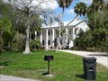
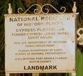 view gallery view galleryN13 km |  Cypress Lodge - Port Mayaca, FL Cypress Lodge - Port Mayaca, FL
in U.S. National Register of Historic Places Cypress Plantation aka Cypress Lodge is a historic inn, one of the few buildings in Port Mayaca. posted by: JL_HSTRE location: Florida date approved: 02/28/2011 last visited: 02/22/2019 |
 view gallery view galleryN13 km |  Cypress Lodge - Port Mayaca, Florida, USA Cypress Lodge - Port Mayaca, Florida, USA
in Photos Then and Now Cypress Lodge, a National Register of Historic Places Listing, formerly known as Cypress Plantation. posted by: BoomersOTR location: Florida date approved: 03/10/2019 last visited: 02/22/2019 |
 view gallery view galleryN13 km |  Cypress Lodge - Port Mayaca, Florida, USA Cypress Lodge - Port Mayaca, Florida, USA
in Wikipedia Entries Cypress Lodge, a National Register of Historic Places Listing, formerly known as Cypress Plantation. posted by: BoomersOTR location: Florida date approved: 03/09/2019 last visited: 02/22/2019 |
 view gallery view galleryN13 km |  Cypress Lodge - Port Mayaca, Florida, USA Cypress Lodge - Port Mayaca, Florida, USA
in News Article Locations Cypress Lodge, a National Register of Historic Places listing, formerly known as Cypress Plantation. posted by: BoomersOTR location: Florida date approved: 03/12/2019 last visited: 02/22/2019 |
 view gallery view galleryN13 km |  Cypress Lodge - Port Mayaca, Florida, USA Cypress Lodge - Port Mayaca, Florida, USA
in Picture Perfect Postcards Cypress Lodge, a National Register of Historic Places listing, formerly known a Cypress Plantation. posted by: BoomersOTR location: Florida date approved: 05/27/2019 last visited: 02/22/2019 |
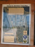 view gallery view galleryN14 km |  Rafael E. Sanchez Trail Rafael E. Sanchez Trail
in The Great Florida Birding Trail This trail is located near Port Mayaca on Lake Okeechobee. posted by:  Team Min Dawg Team Min Dawg location: Florida date approved: 12/21/2006 last visited: 02/22/2019 |
 view gallery view galleryN14 km |  Army Corps Of Engineers - 7A - Port Mayaca, Florida Army Corps Of Engineers - 7A - Port Mayaca, Florida
in U.S. Benchmarks Army Corps Of Engineers benchmark on the Hoover Dike north of the Port Mayaca Lock. posted by: JL_HSTRE location: Florida date approved: 03/20/2011 last visited: 02/22/2019 |
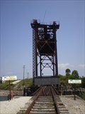 view gallery view galleryN14.2 km |  Vertical Lift Rail Road Bridge near Lake Okeechobee Vertical Lift Rail Road Bridge near Lake Okeechobee
in Railroad Bridges This railroad bridge is located near Port Mayaca on Lake Okeechobee, FL. posted by: Team Min Dawg location: Florida date approved: 11/30/2008 last visited: 03/08/2019 |
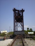 view gallery view galleryN14.2 km |  Vertical Lift Rail Road Bridge near Lake Okeechobee Vertical Lift Rail Road Bridge near Lake Okeechobee
in Vertical Lift Bridges This virtical lift bridge is located near Port Mayaca on Lake Okeechobee. posted by: Team Min Dawg location: Florida date approved: 08/16/2007 last visited: 03/08/2019 |
 view gallery view gallery S15.1 km S15.1 km
|  Tractor Crossing Tractor Crossing
in Uncommon Crossing Signs This sign is located northwest of Belle Glade, FL. posted by: Team Min Dawg location: Florida date approved: 02/15/2008 last visited: 02/12/2014 |
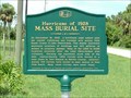 view gallery view galleryN15.6 km | HURRICANE OF 1928 MASS BURIAL SITE in Florida Historical Markers Early residents of Glades had to survive many harsh elements. Their goal to create a thriving farming community was often tested by storms, insects, and the lack of many comforts. In 1928 the Glades area was devastated by a powerful hurricane that threatened to destroy the entire area. Several thousand residents were killed and hundreds of homes were destroyed. Despite the death and damage, those residents that survived continued to develop the area. The Glades eventually became a major agricult posted by: footTRAX location: Florida date approved: 07/16/2006 last visited: 04/05/2020 |
 view gallery view galleryS15.8 km |  Smokey Bear - Belle Glade, Florida, USA Smokey Bear - Belle Glade, Florida, USA
in Smokey Bear Sign Sightings Smokey Bear sign located in Belle Glade, Florida. posted by: BoomersOTR location: Florida date approved: 07/09/2019 last visited: 02/22/2019 |
 view gallery view gallery NE18.3 km NE18.3 km
|  DuPuis Hiking and Biking Trailhead - Indiantown, Florida, USA DuPuis Hiking and Biking Trailhead - Indiantown, Florida, USA
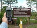
in 'You Are Here' Maps A You Are Here map locate at a Florida Wildlife Management Area trailhead. posted by: BoomersOTR location: Florida date approved: 12/17/2023 last visited: never |
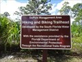 view gallery view galleryNE18.3 km |  DuPuis Hiking & Biking Trailhead - Indiantown, Florida, USA DuPuis Hiking & Biking Trailhead - Indiantown, Florida, USA
in Hiking and walking trailheads A hiking and biking trailhead located in the DuPuis Wildlife Management Area (WMA). posted by: BoomersOTR location: Florida date approved: 12/17/2023 last visited: never |
 view gallery view galleryNE18.3 km | DuPuis Wildlife and Environmental Area in The Great Florida Birding Trail The DuPuis Management Area is a 21,875 acre multi-use natural area located in northwestern Palm Beach and southwestern Martin Counties. The property is interspersed with numerous ponds, wet prairies, cypress domes, pine flatwoods, and remnant Everglades marsh. The area provides miles of hiking and horseback trails, an equestrian center, graded vehicle roads, backpack and group campsites, and seasonal hunting. posted by: footTRAX location: Florida date approved: 07/16/2006 last visited: 02/13/2020 |
 view gallery view galleryNE18.3 km |  DuPuis Wildlife and Environmental Area DuPuis Wildlife and Environmental Area
in Free Campsites The DuPuis Management Area is a 21,875 acre multi-use natural area located in northwestern Palm Beach and southwestern Martin Counties. The property is interspersed with numerous ponds, wet prairies, cypress domes, pine flatwoods, and remnant Everglades marsh. The area provides miles of hiking and horseback trails, an equestrian center, graded vehicle roads, backpack and group campsites, and seasonal hunting. posted by: footTRAX location: Florida date approved: 07/19/2006 last visited: 08/25/2017 |
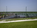 view gallery view gallerySW19.3 km | Moving Bridge in Moving Bridges This swing bridge is located on the edge of Lake Okeechobee in southern Florida. posted by: Team Min Dawg location: Florida date approved: 08/11/2007 last visited: 07/25/2014 |
 view gallery view galleryS20.4 km |  1928 Hurricane - Belle Glade, FL 1928 Hurricane - Belle Glade, FL
in Disaster Memorials A Tribute to those who died in the 1928 Hurricane posted by: crackergals location: Florida date approved: 12/30/2008 last visited: 10/06/2011 |
 view gallery view galleryS20.6 km | Lake Shore High School in Florida Historical Markers Located at 306 SW 10th Street, Belle Glade posted by: Markerman62 location: Florida date approved: 07/18/2023 last visited: never |
 view gallery view galleryS21.1 km |  McDonald's Restaurant - WIFI Hotspot - Main St., Belle Glade, FL McDonald's Restaurant - WIFI Hotspot - Main St., Belle Glade, FL
in Wi-Fi Hotspots McDonald's Restaurant - WIFI Hotspot - 833 S. Main St., Belle Glade, FL posted by: walkingwildly location: Florida date approved: 02/29/2016 last visited: 02/29/2016 |
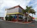 view gallery view galleryS21.1 km |  McDonald's Restaurant - Main Street, Belle Glade, Florida McDonald's Restaurant - Main Street, Belle Glade, Florida
in McDonald's Restaurants McDonald's Restaurant - 833 S. Main Street, Belle Glade, Florida 33430 posted by: walkingwildly location: Florida date approved: 02/29/2016 last visited: 02/29/2016 |
|