 view gallery view gallery SE1 km SE1 km
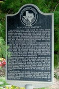
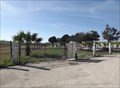
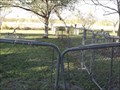
|   Longoria Cemetery Longoria Cemetery
in Texas Historical Markers The Longorias, early Spanish pioneers, settled in the valley in the mid-18th century. The Longoria ranch became one of the largest in the Rio Grande Valley. posted by:  JimmyEv JimmyEv location: Texas date approved: 11/15/2007 last visited: 07/17/2015 |
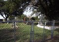
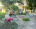 view gallery view gallerySE1 km |  Longoria Cemetery, Santa Maria, Texas, USA Longoria Cemetery, Santa Maria, Texas, USA
in Worldwide Cemeteries U.S. 281 is lined with small, family cemeteries. The plot for the Longoria family, one of the largest landowners in the Valley, now contains almost 400 graves. The gravesites are decorated by family members for Day of the Dead each October. posted by: JimmyEv location: Texas date approved: 03/16/2008 last visited: 12/04/2013 |
 view gallery view gallery SW1.1 km SW1.1 km
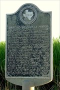
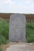
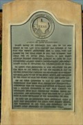
| Rancho de Santa Maria in Texas Historical Markers This ranch, part of the La Feria Grant, has been used at various times by the U.S. Military when trouble sparked on the southern border. posted by: JimmyEv location: Texas date approved: 11/15/2007 last visited: 07/17/2015 |
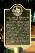 view gallery view gallerySW1.1 km | Our Lady of Visitation Catholic Church in Texas Historical Markers This marker answers the question: "Does it ever snow in the Lower Rio Grande Valley?" posted by: JimmyEv location: Texas date approved: 11/15/2007 last visited: 07/17/2015 |
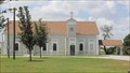
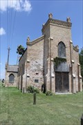 view gallery view gallerySW1.1 km |  "Hope emerges for restoring Our Lady of Visitation" -- Santa Maria TX "Hope emerges for restoring Our Lady of Visitation" -- Santa Maria TX
in News Article Locations A historic 1882 Gothic church in need of renovation was built by the Oblate Fathers of Texas along the Old Military Road in Santa Maria TX, in the news in 2009 posted by:  Benchmark Blasterz Benchmark Blasterz location: Texas date approved: 08/19/2015 last visited: 08/19/2015 |
 view gallery view gallerySW1.1 km |  Our Lady of Visitation -- Santa Maria TX Our Lady of Visitation -- Santa Maria TX
in Roman Catholic Churches The historic 1882 Gothic Roman Catholic church was built by the Missionary Oblate Fathers of Texas along the Old Military Road in Santa Maria TX posted by: Benchmark Blasterz location: Texas date approved: 08/18/2015 last visited: 08/19/2015 |
 view gallery view gallerySW1.1 km | Our Lady of Visitation -- Santa Maria TX in This Old Church A historic 1882 Gothic church in need of renovation was built by the Oblate Fathers of Texas along the Old Military Road in Santa Maria TX posted by: Benchmark Blasterz location: Texas date approved: 08/18/2015 last visited: 08/19/2015 |
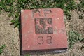 view gallery view gallerySW1.1 km |  AB0912 RP 32 -- Santa Maria TX AB0912 RP 32 -- Santa Maria TX
in U.S. Benchmarks An International Boundary Commission reference post benchmark at the Our Lady of Visitation Catholic Church in Santa Maria, Texas posted by: Benchmark Blasterz location: Texas date approved: 08/18/2015 last visited: 08/19/2015 |
 view gallery view gallery W1.8 km W1.8 km
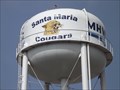
|  Water Tower - Santa Maria TX Water Tower - Santa Maria TX
in Water Towers This Water Tower operated by the Military Highway Water Supply Corporation is Tutt Avenue in Santa Maria, Texas. posted by: PeterNoG location: Texas date approved: 01/11/2014 last visited: 08/18/2015 |
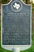 view gallery view galleryW3.9 km | Battle of La Bolsa in Texas Historical Markers A mile to the south, John S. "Rip" Ford's Texas Rangers successfully defended a steamship on the Rio Grande from a raid by Juan N. Cortina. Cortina's raids continued until he escaped into Mexico, where he became a general in the Mexican Army. posted by: JimmyEv location: Texas date approved: 11/15/2007 last visited: 07/17/2015 |
 view gallery view galleryW4.8 km | Zacatal Ranch Cemetery - Relampago TX in Worldwide Cemeteries This Cemetery is 300 feet south of the Military Highway (US 281) on the west side of a small canal, 0.9 miles west of the Cameron County Line and 2.3 miles east of Mercedes Main Canal at Relampago in Hidalgo County, Texas. posted by: PeterNoG location: Texas date approved: 04/10/2014 last visited: 01/19/2014 |
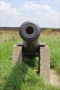 view gallery view gallerySE5 km |  US Army iron 6 pounder cannon -- US 281, Cameron Co. TX US Army iron 6 pounder cannon -- US 281, Cameron Co. TX
in Static Artillery Displays A stray US Army 6 pounder cannon from the Mexican War era stands sentry in a roadside park commemorating the Thornton Skirmish in rural Cameron County posted by: Benchmark Blasterz location: Texas date approved: 09/02/2015 last visited: 07/20/2015 |
 view gallery view gallerySE5 km |  Thornton Skirmish -- Las Rucias TX Thornton Skirmish -- Las Rucias TX
in Battlefields The Thornton Skirmish at Rancho Carrecitos set off the US-Mexican War. posted by: Benchmark Blasterz location: Texas date approved: 08/26/2015 last visited: 07/19/2015 |
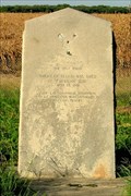 view gallery view gallerySE5 km | Thornton Skirmish in Texas Historical Markers On this spot, American troops were attacked by Mexican troops in 1846 on land claimed by both America and Mexico. posted by: JimmyEv location: Texas date approved: 11/15/2007 last visited: 07/17/2015 |
 view gallery view gallerySE5 km | Alonso de Leon Expeditions in Texas Historical Markers De Leon led expeditionary forces into Texas to find and expel the French. He later led settlers to the Rio Grande Valley to protect the area from future French encroachment. posted by: JimmyEv location: Texas date approved: 11/15/2007 last visited: 07/17/2015 |
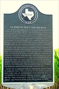 view gallery view galleryW6.1 km | El Horcon Tract and Rio Rico in Texas Historical Markers Perhaps this is a cautionary tale of what might happen to the two miles of American soil between the Rio Grande and the proposed border fence. posted by: JimmyEv location: Texas date approved: 11/15/2007 last visited: 07/17/2015 |
 view gallery view gallerySE6.6 km | Moreno Cemetery - Los Indios TX in Worldwide Cemeteries This Cemetery is right behind Weaver Cemetery #2 which is on J. E. Gerusa Road, 1000 feet southeast of the Military Highway (US Hwy 281) and 1.6 miles west of Los Indios in Cameron County, Texas. posted by: PeterNoG location: Texas date approved: 02/22/2014 last visited: 01/21/2014 |
 view gallery view gallerySE6.6 km | Weaver Cemetery #2 - Los Indios TX in Worldwide Cemeteries This Cemetery is on J. E. Gerusa Road, 1000 feet southeast of the Military Highway (US Hwy 281) and 1.6 miles west of Los Indios in Cameron County, Texas. posted by: PeterNoG location: Texas date approved: 02/22/2014 last visited: 12/13/2013 |
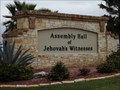 view gallery view gallery N6.9 km N6.9 km
|  Rio Grande Valley Assembly Hall of Jehovah's Witnesses - La Feria, Texas Rio Grande Valley Assembly Hall of Jehovah's Witnesses - La Feria, Texas
in Kingdom Halls of Jehovah's Witnesses This very large Assembly Hall is on South Parker Road about 1.2 miles south of US 83 Business in La Feria, Texas. posted by: PeterNoG location: Texas date approved: 02/05/2014 last visited: 11/30/2013 |
 view gallery view gallery E7.1 km E7.1 km
| Water Tower - Los Indios TX in Water Towers This Military Highway Water Supply Corp Water Tower is on FM 1479 (Rangerville Road), 2/3 mile north of US Hwy 281 (the Military Highway) near Los Indios, Texas. posted by: PeterNoG location: Texas date approved: 03/14/2014 last visited: 07/17/2015 |
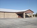 view gallery view galleryN7.1 km | Kingdom Hall of Jehovah's Witnesses - La Feria TX in Kingdom Halls of Jehovah's Witnesses This newer Kingdom Hall of Jehovah's Witnesses is just north of the Rio Grande Valley Assembly Hall on South Parker Road about 1.2 miles south of US 83 Business in La Feria, Texas. posted by: PeterNoG location: Texas date approved: 02/26/2014 last visited: 12/17/2013 |
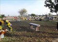 view gallery view gallerySE7.6 km | Las Rucias Memorial Cemetery - Los Indios TX in Worldwide Cemeteries This Cemetery is on the north side of the Military Highway (US Hwy 281), 700 feet east of FM 1479 in Los Indios, Texas. posted by: PeterNoG location: Texas date approved: 03/06/2014 last visited: 01/11/2014 |
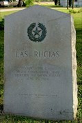 view gallery view gallerySE7.7 km | Las Rucias in Texas Historical Markers It was near here that the Confederate forces commanded by Colonel John S. Ford defeated Union forces and re-took Fort Brown. posted by: JimmyEv location: Texas date approved: 11/15/2007 last visited: 07/17/2015 |
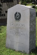 view gallery view gallerySE7.7 km | Las Rucias Skirmish -- Las Rucias TX in Battlefields The peaceful Rio Grande Valley hamlet of Las Rucias was not so quiet on 25 Jun 1864, when the Union Army and Confederate forces clashed here. posted by: Benchmark Blasterz location: Texas date approved: 08/26/2015 last visited: 07/19/2015 |
 view gallery view gallerySE7.7 km | Sacred Heart Catholic Church -- Las Rucias TX in Roman Catholic Churches The beautiful and historic Sacred Heart Catholic Church in Las Rucias, on the Oblate Fathers Historic Trail posted by: Benchmark Blasterz location: Texas date approved: 08/18/2015 last visited: 08/19/2015 |
|