 view gallery view gallery SW60 km SW60 km
|   Valladolid Fountain Valladolid Fountain
in Fountains Nice fountain in the park located in front of the San Gervasio Cathedral. posted by:  tatie tatie location: Yucatán, Mexico date approved: 11/16/2011 last visited: 12/31/2021 |
 view gallery view gallerySW60.8 km |  Valladolid - Yucatan, Mexico Valladolid - Yucatan, Mexico
in City Names in Giant Letters The letters with the name of the city are actually a main touristic attraction in Valladolid posted by: Torgut location: Yucatán, Mexico date approved: 04/09/2023 last visited: never |
 view gallery view gallery S69 km S69 km
|  Stairs of Cobá - Cobá, Playa del Carmen, Quintana Roo, México Stairs of Cobá - Cobá, Playa del Carmen, Quintana Roo, México
in Outdoor Stairways 120 stairs posted by: Ariberna location: Quintana Roo, Mexico date approved: 08/28/2021 last visited: 12/31/2021 |
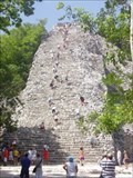
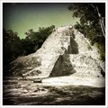
 view gallery view galleryS69 km |  The Nohoch Mul pyramid - Cobá, Playa del Carmen, Quintana Roo, México The Nohoch Mul pyramid - Cobá, Playa del Carmen, Quintana Roo, México
in Satellite Imagery Oddities Nohoch Mul is the tallest pyramid on the Yucatán peninsula. posted by: Ariberna location: Quintana Roo, Mexico date approved: 08/28/2021 last visited: 12/31/2021 |
 view gallery view galleryS69 km |  The tallest pyramid in the Riviera Maya - Cobá, Playa del Carmen, Quintana Roo, México The tallest pyramid in the Riviera Maya - Cobá, Playa del Carmen, Quintana Roo, México
in News Article Locations The highest and you can climb it. posted by: Ariberna location: Quintana Roo, Mexico date approved: 09/28/2020 last visited: 12/31/2021 |
 view gallery view galleryS69 km |  Cobá - Cobá, Playa del Carmen, Quintana Roo, México Cobá - Cobá, Playa del Carmen, Quintana Roo, México
in Wikipedia Entries Cobá is an archaeological sitew with mayan ruins posted by: Ariberna location: Quintana Roo, Mexico date approved: 09/19/2020 last visited: 12/31/2021 |
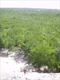 view gallery view galleryS69 km |  View from Nohoch nul - Cobá, Playa del Carmen, Quintana Roo, México View from Nohoch nul - Cobá, Playa del Carmen, Quintana Roo, México
in Scenic Overlooks You see the jungle posted by: Ariberna location: Quintana Roo, Mexico date approved: 09/05/2021 last visited: 09/07/2021 |
 view gallery view galleryS69 km |  Pirámide Nohoch nul - Cobá, Playa del Carmen, Quintana Roo, México Pirámide Nohoch nul - Cobá, Playa del Carmen, Quintana Roo, México
in New World Ancient Evidence The highest of Yucatán posted by: Ariberna location: Quintana Roo, Mexico date approved: 09/19/2020 last visited: 12/31/2021 |
 view gallery view galleryS69 km |  Pirámide Nohoch nul - Cobá, Playa del Carmen, Quintana Roo, México Pirámide Nohoch nul - Cobá, Playa del Carmen, Quintana Roo, México
in Official Local Tourism Attractions The highest of Yucatán posted by: Ariberna location: Quintana Roo, Mexico date approved: 09/19/2020 last visited: 12/31/2021 |
 view gallery view galleryS69 km |  Highest piramid of Yucatán - Cobá, Playa del Carmen, Quintana Roo, México Highest piramid of Yucatán - Cobá, Playa del Carmen, Quintana Roo, México
in Superlatives The highest piramid of Yucatán with 42 m posted by: Ariberna location: Quintana Roo, Mexico date approved: 09/19/2020 last visited: 12/31/2021 |
 view gallery view galleryS69 km |  Pirámide Nohoch nul - Cobá, Playa del Carmen, Quintana Roo, México Pirámide Nohoch nul - Cobá, Playa del Carmen, Quintana Roo, México
in Pyramids The highest and you can climb it posted by: Ariberna location: Quintana Roo, Mexico date approved: 09/19/2020 last visited: 12/31/2021 |
 view gallery view galleryS69 km |  Pirámide Nohoch Nul Lucky7 - Cobá, Playa del Carmen, Quintana Roo, México Pirámide Nohoch Nul Lucky7 - Cobá, Playa del Carmen, Quintana Roo, México
in Lucky 7 8 for 1 in Nohoch Nul posted by: Ariberna location: Quintana Roo, Mexico date approved: 09/11/2021 last visited: 12/31/2021 |
 view gallery view galleryS69 km |  Pirámide Nohoch nul - Cobá, Playa del Carmen, Quintana Roo, México Pirámide Nohoch nul - Cobá, Playa del Carmen, Quintana Roo, México
in Preserved Architectural Remnants and Ruins The highest of Yucatán posted by: Ariberna location: Quintana Roo, Mexico date approved: 09/18/2020 last visited: 12/31/2021 |
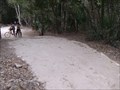 view gallery view galleryS70.2 km |  Mayan road Mayan road
in Ancient Traces and Roads Ancient Mayan Limestone road posted by:  nmartin nmartin location: Quintana Roo, Mexico date approved: 01/30/2011 last visited: 12/31/2021 |
 view gallery view galleryS70.3 km |  Coba Zip-line - Coba, Mexico Coba Zip-line - Coba, Mexico
in Zip-line It's 125ft high, it's 500 meters long and it's over a lake! Adrenalin? Check! posted by: SUp3rFM & Cruella location: Quintana Roo, Mexico date approved: 10/12/2011 last visited: 02/18/2019 |
 view gallery view galleryS70.3 km | Coba, Mexico in New World Ancient Evidence Coba (Cobá in the Spanish language) is a large ruined city of the Pre-Columbian Maya civilization, located in the state of Quintana Roo, Mexico posted by: SUp3rFM & Cruella location: Quintana Roo, Mexico date approved: 10/12/2011 last visited: 12/31/2021 |
 view gallery view gallery E87.5 km E87.5 km
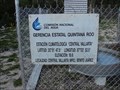
|  N 20 51' 47.5" W 87 02' 52.5" Climatological Station, Central Vallarta, Mexico N 20 51' 47.5" W 87 02' 52.5" Climatological Station, Central Vallarta, Mexico
in Permanent Geographic Coordinates A climatological Station located in Cental Vallarta in the Municipality of Benito Juarez, in South East Yucatan, Mexico. posted by:  Phoneguy Canuck Phoneguy Canuck location: Quintana Roo, Mexico date approved: 04/14/2009 last visited: never |
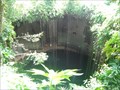
 view gallery view gallerySW88.7 km |  Cenote Sagrado - Mexico Cenote Sagrado - Mexico
in Holy Wells Cenote Sagrado is located in Mexico. posted by: tatie location: Yucatán, Mexico date approved: 03/04/2014 last visited: 02/13/2022 |
 view gallery view gallerySW88.7 km |  Cenote Sagrado - Mexico Cenote Sagrado - Mexico
in Natural Sinkholes Cenote Sagrado is located in Mexico. posted by: tatie location: Yucatán, Mexico date approved: 02/25/2014 last visited: 02/13/2022 |
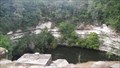
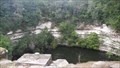
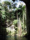 view gallery view gallerySW88.8 km |  "Sacred Blue Well", IL-Kil Cenote, Chichen-itza, Mexico "Sacred Blue Well", IL-Kil Cenote, Chichen-itza, Mexico
in Swimming Holes Cenote Ik Kil is a perfectly round, well-type cenote with an diameter of 60m and a depth of 40m. It is an open shaft, the water level is 25m below the surface. A grand stairway leads visitors down into the water, which is ideal for swimming posted by: PersonsMD location: Yucatán, Mexico date approved: 09/26/2009 last visited: 12/31/2021 |
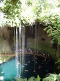 view gallery view gallerySW88.8 km | Ik Kil - Pisté, Yucatán, Mexico in Wikipedia Entries Incredible with its 60m deep and its dangling roots posted by: Ariberna location: Yucatán, Mexico date approved: 08/28/2020 last visited: 04/28/2023 |
 view gallery view gallerySW88.8 km | Cenote Ik-Kil - Pisté, Yucatán, Mexico in Official Local Tourism Attractions Incredible with its 60m deep and its dangling roots posted by: Ariberna location: Yucatán, Mexico date approved: 08/28/2020 last visited: 04/28/2023 |
 view gallery view gallerySW88.8 km | Ik Kil Cenote - Pisté, Yucatán, Mexico in Natural Sinkholes Cenote Ik Kil (cenote means “natural well” in Spanish) is a large sinkhole on Mexico’s Yucatan Peninsula that’s sacred to the Mayans. The peninsula’s unique composition of porous limestone has resulted in several of these water-filled sinkholes. posted by: SUp3rFM & Cruella location: Yucatán, Mexico date approved: 10/12/2011 last visited: 12/31/2021 |
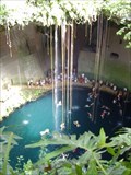 view gallery view gallerySW88.8 km |  Cenote Ik-Kil - Xcalacoop, Mexico Cenote Ik-Kil - Xcalacoop, Mexico
in Roadside Attractions A magical sinkhole on the Yucatan peninsula adorned with mini waterfalls and hanging vines. posted by: Ariberna location: Yucatán, Mexico date approved: 07/31/2021 last visited: 04/28/2023 |
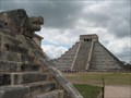 view gallery view gallerySW89.2 km | El Castillo (Chichen Itza) in Pyramids The massive central pyramid at the pre-Columbian Mayan city of Chichen Itza. posted by: Shorelander location: Yucatán, Mexico date approved: 04/27/2008 last visited: 01/31/2024 |
|