 view gallery view gallery SE9.5 km SE9.5 km
|   Caracol - Mayan Ruins - Belize Caracol - Mayan Ruins - Belize
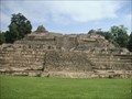
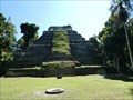
in Preserved Architectural Remnants and Ruins Caracol or El Caracol is the name given to a large ancient Maya archaeological site, located in what is now the Cayo District of Belize. It is situated approximately 25 miles south of Xunantunich and San Ignacio Cayo, at an elevation of 1500 feet. posted by:  Mountain_Wanderer Mountain_Wanderer location: Belize date approved: 01/03/2009 last visited: 08/16/2023 |
 view gallery view gallery N36 km N36 km
|  Hand Cranked Ferry Mopan River - Belize Hand Cranked Ferry Mopan River - Belize
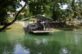
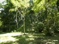
in Ferries and Ferry Landings The you must cross the Hand Cranked Ferry on the Mopan River in Belize to get to the Xunatunich Mayan Ruins. Locals sell their hand made crafts along side the road here. posted by: kJfishman location: Belize date approved: 07/23/2014 last visited: 11/12/2014 |
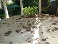
 view gallery view galleryN36.2 km |  Xunantunich Mayan Ruins - Belize Xunantunich Mayan Ruins - Belize
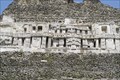
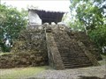
in Frieze Art Some of the oldest Frieze Art on the planet! posted by: kJfishman location: Belize date approved: 07/27/2014 last visited: 11/12/2014 |
 view gallery view galleryN36.2 km |  Xunantunich Xunantunich
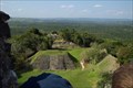
in New World Ancient Evidence This is the location for an ancient Mayan ruin in western Belize. posted by:  rob-rover rob-rover location: Belize date approved: 11/25/2007 last visited: 11/12/2014 |
 view gallery view gallery NW43.1 km NW43.1 km
|  Yaxha-Nakum-Naranjo National Park - Peten, Guatemala Yaxha-Nakum-Naranjo National Park - Peten, Guatemala
in National Parks of the World A National Park with a multitude of Mayan ruins. posted by: Metro2 location: Guatemala date approved: 03/06/2018 last visited: 03/05/2018 |
 view gallery view galleryNW43.1 km |  Cultural Triangle Yaxha-Nakum-Naranjo National Park - Peten, Guatemala Cultural Triangle Yaxha-Nakum-Naranjo National Park - Peten, Guatemala
in Wikipedia Entries A National Park with a multitude of Mayan ruins. posted by: Metro2 location: Guatemala date approved: 03/21/2018 last visited: 03/05/2018 |
 view gallery view galleryNW45.4 km | Yaxha Twin Pyramid Complex - Yaxha, Guatemala in New World Ancient Evidence A still only partially-excavated twin Mayan pyramid complex. posted by: Metro2 location: Guatemala date approved: 03/24/2018 last visited: 03/05/2018 |
 view gallery view galleryNW45.4 km |  Yaxha Twin Pyramid Complex - Yaxha, Guatemala Yaxha Twin Pyramid Complex - Yaxha, Guatemala
in Pyramids A still only partially-excavated twin Mayan pyramid complex. posted by: Metro2 location: Guatemala date approved: 04/17/2018 last visited: 03/06/2018 |
 view gallery view galleryNW45.4 km | Yaxha Twin Pyramid Complex - Yaxha, Guatemala in Preserved Architectural Remnants and Ruins A still only partially-excavated twin Mayan pyramid complex. posted by: Metro2 location: Guatemala date approved: 03/23/2018 last visited: 03/05/2018 |
 view gallery view galleryNW46.5 km | Topoxte - Peten, Guatemala in Wikipedia Entries This Mayan site was occupied until about 900 and reoccupied during the Postclassic at approximately 1100 until re-abandoned around 1450. posted by: Metro2 location: Guatemala date approved: 04/03/2018 last visited: 03/05/2018 |
 view gallery view galleryNW46.5 km | Topoxte Building C - Peten, Guatemala in Preserved Architectural Remnants and Ruins This Mayan site was occupied until about 900 and reoccupied during the Postclassic at approximately 1100 until re-abandoned around 1450. posted by: Metro2 location: Guatemala date approved: 04/03/2018 last visited: 03/05/2018 |
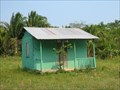 view gallery view gallery S62.6 km S62.6 km
|  Blue Creek Village Library - Belize Blue Creek Village Library - Belize
in Libraries A very tiny and remote Belizean village library. posted by: tsunrisebey location: Belize date approved: 12/29/2007 last visited: 01/16/2012 |
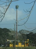 view gallery view gallery NE65.3 km NE65.3 km
|  Palm Tree at national fairgrounds - Belmopan, Belize Palm Tree at national fairgrounds - Belmopan, Belize
in Disguised Cell Towers Cell tower roughly hidden as a palm tree. posted by: vhasler location: Belize date approved: 03/07/2017 last visited: never |
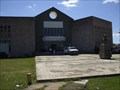
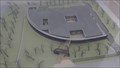
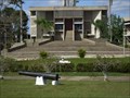 view gallery view galleryNE65.3 km |  Belmopan Capitol Center Belmopan Capitol Center
in Capitol Buildings Belmopan Capitol Government Center posted by: RPKBelize location: Belize date approved: 11/09/2010 last visited: never |
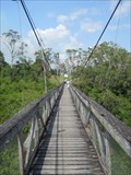 view gallery view galleryNE65.5 km |  Swinging Bridge over Belize River - Roaring Creek, Belize Swinging Bridge over Belize River - Roaring Creek, Belize
in Pedestrian Suspension Bridges Swinging bridge over Belize River to connect residents on the north side with the market district. posted by: vhasler location: Belize date approved: 03/18/2017 last visited: never |
 view gallery view galleryNW65.8 km |  Tikal - Peten, Guatemala Tikal - Peten, Guatemala
in 3D Map Models of Our World and Beyond A map model of the Mayan City of Tikal. posted by: Metro2 location: Guatemala date approved: 04/20/2018 last visited: 03/07/2018 |
 view gallery view galleryNE65.8 km | George Price Center for Education & Developement in Libraries This is a Center in the Capital named for the First Prime Minister of Belize after it became a nation in 1981. posted by: RPKBelize location: Belize date approved: 11/08/2010 last visited: never |
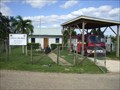 view gallery view galleryNE66.1 km |  Sanmartine Fire Station Sanmartine Fire Station
in Firehouses Small Sub Station to the Belmopan (The smallest Capitol in the world)Fire Station. posted by: RPKBelize location: Belize date approved: 11/19/2010 last visited: never |
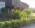 view gallery view galleryNE67.3 km |  Spider at Art Box - Belmopan, Belize Spider at Art Box - Belmopan, Belize
in Insect Sculptures Wire frame spider outside souvenir shop posted by: vhasler location: Belize date approved: 03/06/2017 last visited: never |
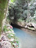 view gallery view galleryNE68.9 km | ") Caves Branch Cave, Nohoch Che'en Caves Branch Archaeological Reserve, Belize Caves Branch Cave, Nohoch Che'en Caves Branch Archaeological Reserve, Belize
in Cave Entrances (Natural) When you visit Belize, you go cave tubing! This is the first exit and second entrance of this cave system. The river emerges here and then enters its subterranean passage. You can ride an inner tube through the cave system to enjoy the cave. posted by: PersonsMD location: Belize date approved: 01/13/2009 last visited: 01/31/2011 |
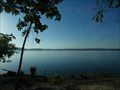 view gallery view gallery W69.8 km W69.8 km
| Lake Petén Itzá - Guatemala in Wikipedia Entries This is the second largest lake in Guatemala. posted by: Metro2 location: Guatemala date approved: 03/22/2018 last visited: 03/06/2018 |
 view gallery view galleryW69.8 km |  Camino Real Hotel - Antigua, Guatemala Camino Real Hotel - Antigua, Guatemala
in Bookcrossing Zones Located at 7a Calle Poniente
Antigua, Sacatepéquez 33b
Guatemala posted by: Metro2 location: Guatemala date approved: 03/21/2018 last visited: 03/06/2018 |
 view gallery view galleryW69.8 km |  Camino Real Hotel - Tikal, Guatemala Camino Real Hotel - Tikal, Guatemala
in Recommended Accommodation Located at Lote 77 Parcelamiento Tayasal, 17002 San José, Guatemala posted by: Metro2 location: Guatemala date approved: 03/21/2018 last visited: 03/06/2018 |
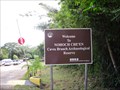 view gallery view galleryNE70.2 km | Nohoch Che'en Caves Branch Archaeological Reserve, Belize in National Parks of the World Nohoch Che'en is known for it's underground rivers and Myan cultural history posted by: PersonsMD location: Belize date approved: 12/27/2008 last visited: 01/31/2011 |
 view gallery view galleryNW73.4 km |  Centro de Conservacion e Invesitgacion de Tikal - Tiakl, Guatemala Centro de Conservacion e Invesitgacion de Tikal - Tiakl, Guatemala
in Exact Replicas Located near the entrance to the ancient Mayan ruins of Tikal complex. posted by: Metro2 location: Guatemala date approved: 04/20/2018 last visited: 03/07/2018 |
|